Approximate Location Map
Large Map »
Latitude: 51.2029 / 51°12'10"N
Longitude: 1.3891 / 1°23'20"E
OS Eastings: 636844
OS Northings: 150308
OS Grid: TR368503
Mapcode National: GBR X23.J0R
Mapcode Global: VHMDN.1167
Plus Code: 9F33693Q+4J
Entry Name: Wingrove House
Listing Date: 8 February 1974
Grade: II
Source: Historic England
Source ID: 1069861
English Heritage Legacy ID: 177027
ID on this website: 101069861
Location: Upper Walmer, Dover, Kent, CT14
County: Kent
District: Dover
Civil Parish: Walmer
Built-Up Area: Deal
Traditional County: Kent
Lieutenancy Area (Ceremonial County): Kent
Tagged with: House
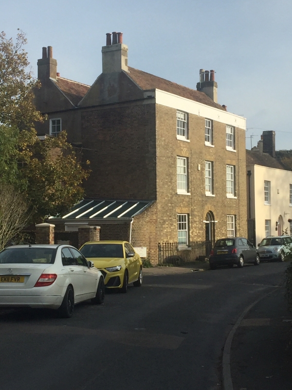
CHURCH STREET
1.
1035
(North East Side)
WALMER
No 24
(Wingrove House)
TR 35 SE 5/1
II
2.
Early C19. 2 parallel ranges. 3 storeys white brick with yellow brick dressings.
Stuccoed parapet. 3 sashes with glazing bars intact. Round-headed doorcase
in recessed brick arch with semi-circular fanlight. L-shaped wing at the north
east corner.
Listing NGR: TR3685250321
External links are from the relevant listing authority and, where applicable, Wikidata. Wikidata IDs may be related buildings as well as this specific building. If you want to add or update a link, you will need to do so by editing the Wikidata entry.


Other nearby listed buildings
