Latitude: 51.127 / 51°7'37"N
Longitude: 0.7558 / 0°45'20"E
OS Eastings: 592929
OS Northings: 140026
OS Grid: TQ929400
Mapcode National: GBR RWX.CVR
Mapcode Global: VHKKL.1XXX
Plus Code: 9F324QG4+R8
Entry Name: Newtown
Listing Date: 10 October 1980
Grade: II
Source: Historic England
Source ID: 1070810
English Heritage Legacy ID: 180593
ID on this website: 101070810
Location: Bethersden, Ashford, Kent, TN26
County: Kent
District: Ashford
Civil Parish: Bethersden
Built-Up Area: Bethersden
Traditional County: Kent
Lieutenancy Area (Ceremonial County): Kent
Tagged with: Building
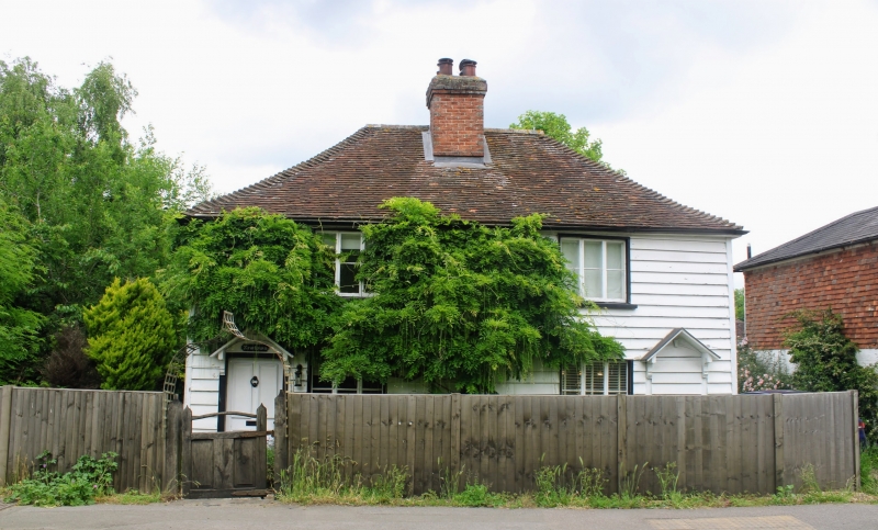
1.
5272 BETHERSDEN ASHFORD ROAD
Newtown
TQ 9240 21/66
II GV
2.
Early C19 pair of cottages. Two storeys weatherboarded. Hipped tiled roof.
Two casements. Pedimented weatherboards. One doorcase now modernised.
Listing NGR: TQ9292940024
External links are from the relevant listing authority and, where applicable, Wikidata. Wikidata IDs may be related buildings as well as this specific building. If you want to add or update a link, you will need to do so by editing the Wikidata entry.


Other nearby listed buildings