Approximate Location Map
Large Map »
Latitude: 54.1352 / 54°8'6"N
Longitude: -2.6163 / 2°36'58"W
OS Eastings: 359828
OS Northings: 471213
OS Grid: SD598712
Mapcode National: GBR BN5M.CD
Mapcode Global: WH951.SBB7
Plus Code: 9C6V49PM+3F
Entry Name: Milestone
Listing Date: 4 December 1985
Grade: II
Source: Historic England
Source ID: 1071671
English Heritage Legacy ID: 182459
ID on this website: 101071671
Location: Melling, Lancaster, Lancashire, LA6
County: Lancashire
District: Lancaster
Civil Parish: Melling-with-Wrayton
Traditional County: Lancashire
Lieutenancy Area (Ceremonial County): Lancashire
Church of England Parish: Tunstall St John the Baptist and Melling St Wilfred and Leck St Peter
Church of England Diocese: Blackburn
Tagged with: Milestone
SD 57 SE
4/161
MELLING-WITH-WRAYTON
MAIN STREET (east side)
Milestone
GV
II
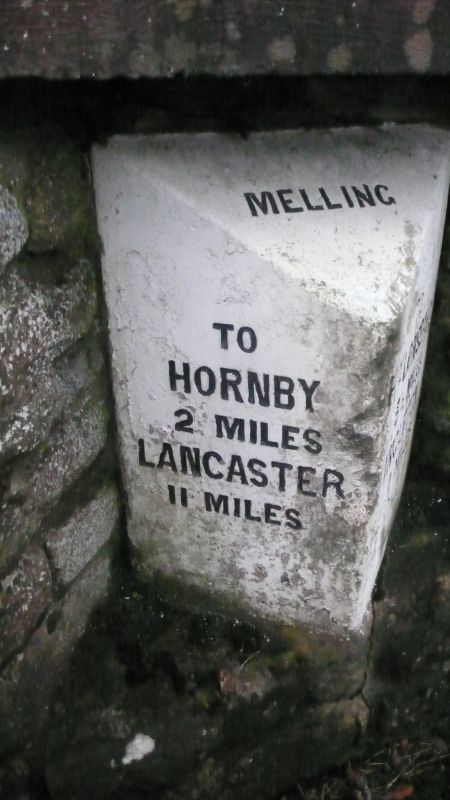
Milestone, probably mid C19, sandstone. Triangular plan, with sloping top inscribed: 'MELLING'. Left-hand face inscribed: 'TO/ HORNBY/ 2 MILES/ LANCASTER /11 MILES.' Right-hand face inscribed: 'TO/ Ky LONSDALE/ 5½ MILES/ INGLETON/ 7 MILES.'
Listing NGR: SD5982871215
External links are from the relevant listing authority and, where applicable, Wikidata. Wikidata IDs may be related buildings as well as this specific building. If you want to add or update a link, you will need to do so by editing the Wikidata entry.


Other nearby listed buildings
