Latitude: 54.1354 / 54°8'7"N
Longitude: -2.6162 / 2°36'58"W
OS Eastings: 359836
OS Northings: 471241
OS Grid: SD598712
Mapcode National: GBR BN5M.D9
Mapcode Global: WH951.SBD1
Plus Code: 9C6V49PM+5G
Entry Name: Crowtrees Farmhouse and Barn Adjoining to South-West
Listing Date: 4 December 1985
Grade: II
Source: Historic England
Source ID: 1362561
English Heritage Legacy ID: 182465
ID on this website: 101362561
Location: Melling, Lancaster, Lancashire, LA6
County: Lancashire
District: Lancaster
Civil Parish: Melling-with-Wrayton
Traditional County: Lancashire
Lieutenancy Area (Ceremonial County): Lancashire
Church of England Parish: Tunstall St John the Baptist and Melling St Wilfred and Leck St Peter
Church of England Diocese: Blackburn
Tagged with: Farmhouse
MELLING-WITH-WRAYTON MAIN STREET (west side) SD 57 SE
4/167 Crowtrees Farmhouse and barn adjoining to south-west
GV II
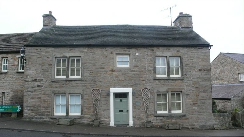
House, late C17th, altered c.1800. Sandstone rubble with tile roof. T-plan. 2 storeys with attic, 2 bays. Windows have plain stone surrounds, a central flat-faced mullion, and modern frames with glazing bars. The door, between bays, has a plain stone surround. Above is the surround of a blocked mullioned window. Straight joints show where other C17th windows have been removed. Gable chimneys, the right-hand one having a cap carried on wooden corbels. On each side of this projecting cap the gable wall has a one-light chamfered attic window, one now blocked. The north wall of the rear wing has 2 chamfered window surrounds on the 1st floor. In the angle with the front range is a lean-to porch with cyma-moulded door surround. Above is a plaque inscribed 'RR 1792' re-set from a farm building. The barn adjoining at the left of the front of the house has a stone slate roof and a wide entrance with external sliding door. Above to the right is a pitching hole with plain reveals. To the left is a modern ground-floor.door with plain reveal The front wall also has breathers and putlog holes.
Listing NGR: SD5983671242
External links are from the relevant listing authority and, where applicable, Wikidata. Wikidata IDs may be related buildings as well as this specific building. If you want to add or update a link, you will need to do so by editing the Wikidata entry.


Other nearby listed buildings