Approximate Location Map
Large Map »
Latitude: 53.7517 / 53°45'6"N
Longitude: -2.3643 / 2°21'51"W
OS Eastings: 376073
OS Northings: 428436
OS Grid: SD760284
Mapcode National: GBR CTX1.XV
Mapcode Global: WH96X.NYBQ
Plus Code: 9C5VQJ2P+M7
Entry Name: Numbers 53, 55 (Warners Arms) and 57
Listing Date: 9 March 1984
Grade: II
Source: Historic England
Source ID: 1072761
English Heritage Legacy ID: 183838
ID on this website: 101072761
Location: Accrington, Hyndburn, Lancashire, BB5
County: Lancashire
District: Hyndburn
Town: Hyndburn
Electoral Ward/Division: Barnfield
Parish: Non Civil Parish
Built-Up Area: Accrington
Traditional County: Lancashire
Lieutenancy Area (Ceremonial County): Lancashire
Church of England Parish: Accrington St James
Church of England Diocese: Blackburn
Tagged with: Building
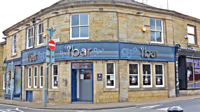
ACCRINGTON WARNER STREET
SD 72 NE
7/38 Nos. 53, 55 (Warners Arms) and 57
-
- II
Public house, c.1830. Dressed sandstone, slate roof with chimneys on
the ridge and at the gable ends. Double-pile plan. Two storeys;
rusticated quoins at left corner, moulded gutter cornice. Symmetrical
facade of 5 bays arranged a-b-c-b-a; the 2nd and 4th are wide segmental
2-storey bays flanking a narrow centre which has a round-headed doorway
with simple imposts and a keystone, containing panelled double doors;
trio 1st and 5th have separate doorways flanked by windows. All windows
are sashed (most without glazing bars), all have jambs with moulded
capitals; ground floor has 8 windows, coupled in the bays, 1st floor has
5; all windows in bays have curved glazing.
Listing NGR: SD7607328436
External links are from the relevant listing authority and, where applicable, Wikidata. Wikidata IDs may be related buildings as well as this specific building. If you want to add or update a link, you will need to do so by editing the Wikidata entry.


Other nearby listed buildings
