Approximate Location Map
Large Map »
Latitude: 53.9213 / 53°55'16"N
Longitude: -2.1931 / 2°11'35"W
OS Eastings: 387412
OS Northings: 447257
OS Grid: SD874472
Mapcode National: GBR FR33.Z2
Mapcode Global: WHB7C.8PWQ
Plus Code: 9C5VWRC4+GP
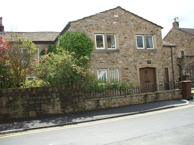
Entry Name: Hen House Farmhouse
Listing Date: 29 January 1988
Grade: II
Source: Historic England
Source ID: 1073418
English Heritage Legacy ID: 186135
ID on this website: 101073418
Location: Croft, Pendle, Lancashire, BB18
County: Lancashire
District: Pendle
Civil Parish: Barnoldswick
Built-Up Area: Barnoldswick
Traditional County: Yorkshire
Lieutenancy Area (Ceremonial County): Lancashire
Tagged with: Farmhouse
SD 84 NE BARNOLDSWICK FERN BANK AVENUE
3/11 Hen House Farmhouse
-
- II
Farmhouse. C17, altered C18. Random rubble with stone slate roof. 2 storeys.
Plain doorway. 2 windows in ground storey have most mullions removed but moulded
dripstone remains to left. 3 casement windows on first floor are C18. Barn to
left not included.
Listing NGR: SD8741247257
External links are from the relevant listing authority and, where applicable, Wikidata. Wikidata IDs may be related buildings as well as this specific building. If you want to add or update a link, you will need to do so by editing the Wikidata entry.


Other nearby listed buildings
