Latitude: 51.1462 / 51°8'46"N
Longitude: 0.3426 / 0°20'33"E
OS Eastings: 563954
OS Northings: 141157
OS Grid: TQ639411
Mapcode National: GBR NR6.3FK
Mapcode Global: VHHQF.WGH5
Plus Code: 9F3248WV+F2
Entry Name: The Forresters
Listing Date: 24 August 1990
Grade: II
Source: Historic England
Source ID: 1074942
English Heritage Legacy ID: 438453
ID on this website: 101074942
Location: Romford, Tunbridge Wells, Kent, TN2
County: Kent
District: Tunbridge Wells
Civil Parish: Pembury
Built-Up Area: Pembury
Traditional County: Kent
Lieutenancy Area (Ceremonial County): Kent
Church of England Parish: Pembury St Peter
Church of England Diocese: Rochester
Tagged with: Building
TQ 64 SW PEMBURY ROMFORD ROAD
5/423 The Forresters
II
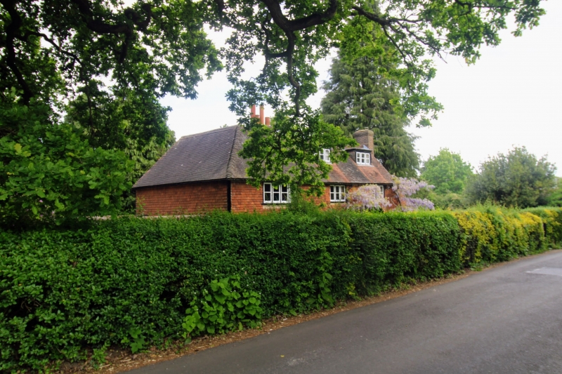
Former farmhouse, once a public house. Mid/late C17, enlarged and modernised
circa 1930. Original house is a tile-hung timber-frame on brick footings, the
extension is stretcher bond red brick to first floor level with tile-hung
timber framing above. brick stacks and chimneyshafts. peg-tile roof.
Plan: L-plan house. The main block faces south south east, say south. It
has a 3-room plan. An axial stack between the centre and left rooms serves
back-to-back fireplaces and the right room has a projecting end stack. In
fact the left end room is the front room of a crosswing projecting to rear
which was added circa 1930 with a new kitchen and staircase built behind the
rest of the main block. Thus the original house had a 2-room plan; a larger
heated main living room to right and originally unheated service room to left.
The rear corner fireplace there was probably inserted in the C19. The
partition between these 2 rooms has been removed.
House is 2 storeys with attics in the roofspace of the C17 section and a
secondary lean-to outshot on the right (east) end.
Exterior: Irregular 3-window front of C20 casements with glazing bars and the
original part has 2 flat-roofed dormers. Front doorway is right of centre and
it contains a late C19/early C20 part-glazed plank door behind a contemporary
gabled porch with wavy bargeboards. The main roof is gabled to right and
hipped to right over the extension.
Interior: The framed structure of the C17 house appears to be well-preserved.
The beams are chamfered with some scroll stops. Wall posts with formed jowls
carry the tie beams but common rafter roof, a couple of them with high curving
collars.
Up until 1917 the house was known as the Foresters Arms and was licensed to
sell beer and tobacco. Apparently it was locally known as 'The Peep and Slip-
it'.
.
Source Mary Standen. Pembury in the Past (1984) p.17.
Listing NGR: TQ6395441157
External links are from the relevant listing authority and, where applicable, Wikidata. Wikidata IDs may be related buildings as well as this specific building. If you want to add or update a link, you will need to do so by editing the Wikidata entry.


Other nearby listed buildings