Latitude: 52.4801 / 52°28'48"N
Longitude: -1.9001 / 1°54'0"W
OS Eastings: 406878
OS Northings: 286918
OS Grid: SP068869
Mapcode National: GBR 608.BT
Mapcode Global: VH9YX.0XTL
Plus Code: 9C4WF3JX+3W
Entry Name: Midland Bank
Listing Date: 25 April 1952
Last Amended: 8 July 1982
Grade: II
Source: Historic England
Source ID: 1075753
English Heritage Legacy ID: 216772
ID on this website: 101075753
Location: Birmingham, West Midlands, B2
County: Birmingham
Parish: Non Civil Parish
Built-Up Area: Birmingham
Traditional County: Warwickshire
Lieutenancy Area (Ceremonial County): West Midlands
Church of England Parish: Cathedral Church of St Philip Birmingham
Church of England Diocese: Birmingham
Tagged with: Bank building
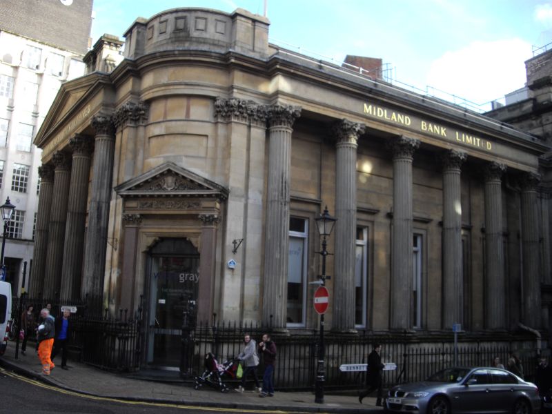
BENNETT'S HILL 1. 5104 City Centre B2 Mos 26 to 33 (consec) (Midland Bank) (formerly listed as Midland Bank under Waterloo Street SP 0686 NE 33/6 25.4.52 II GV 2. 1830, by Rickman and Eutchinson, altered in 1868 by H R Yeoville Thomason. Stone. Five bays plus the entrance bay on the corner and a seventh bay to the right where there is a subsidiary entrance. Giant Corinthian columns with entablature in front of a wall with tall narrow windows in moulded surrounds. Bold Corinthian pilasters about the later pedimented principal entrance on the angle. The return of Waterloo Street with a Corinthian tetrastyle portico to the entablature and pediment. Behind it, tall windows as the others. Early C19 iron railings. Important corner site.
Listing NGR: SP0687886918
External links are from the relevant listing authority and, where applicable, Wikidata. Wikidata IDs may be related buildings as well as this specific building. If you want to add or update a link, you will need to do so by editing the Wikidata entry.


Other nearby listed buildings