Approximate Location Map
Large Map »
Latitude: 52.242 / 52°14'31"N
Longitude: 0.7147 / 0°42'52"E
OS Eastings: 585441
OS Northings: 263901
OS Grid: TL854639
Mapcode National: GBR QF0.FHG
Mapcode Global: VHKD4.BXP3
Plus Code: 9F426PR7+RV
Entry Name: 47 and 47A, College Street
Listing Date: 12 July 1972
Last Amended: 30 October 1997
Grade: II
Source: Historic England
Source ID: 1076948
English Heritage Legacy ID: 466746
ID on this website: 101076948
Location: Bury St Edmunds, West Suffolk, IP33
County: Suffolk
District: West Suffolk
Civil Parish: Bury St Edmunds
Built-Up Area: Bury St Edmunds
Traditional County: Suffolk
Lieutenancy Area (Ceremonial County): Suffolk
Church of England Parish: Bury St Edmunds St Mary
Church of England Diocese: St.Edmundsbury and Ipswich
Tagged with: Building
BURY ST EDMUNDS
TL8563NW COLLEGE STREET
639-1/15/278 (West side)
12/07/72 Nos.47 AND 47A
(Formerly Listed as:
COLLEGE STREET
(West side)
Nos.47 AND 48)
GV II
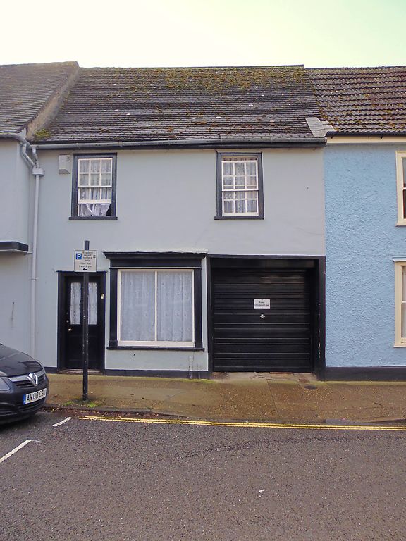
Former shop and house, now shop and office premises. Mid to
late C16 with extensions at the rear, part single-storey and
of various dates; an early C19 front. Timber-framed and
rendered front range; rear extensions in a variety of
materials including flint and red brick. C20 plaintiles.
EXTERIOR: 2 window range to front: 12-pane sashes in flush
cased frames. On the ground storey, a small C19 shop window in
a plain architrave with projecting moulded cornice has a
single vertical bar dividing the glazing. 4-panel door, the
top 2 panels glazed, and a late C20 garage door leading into
the rear yard.
INTERIOR: the front range has chamfered main cross-beams with
curved step stops to the 2-bay ground storey room, which now
has part of one bay taken up by the side entry. The rear wall
has been removed and a small extension encloses a later
chimney-stack. On the upper storey, 2 rooms have been made
into one by removing the infill between the studs in the
partition wall. The studding is widely spaced and the end
truss against No.46 (qv) has deep jowls to the chamfered main
posts and long arched braces. Roof inaccessible.
The extensions at the rear overlap with part of No.46 and
across the yard are further outbuildings which structurally
form part of the rear of No.48 (qv), so that the property has
complex boundaries. A derelict 2-bay range immediately behind
No.48 has a C19 exterior in flint and brick with
segmental-arched openings to the window and door and a C16
timber-framed interior with a plain heavy beam-and-joist
ceiling. A loft above with renewed roof. On the inner wall,
the remains of a large open fireplace.
Listing NGR: TL8544163901
External links are from the relevant listing authority and, where applicable, Wikidata. Wikidata IDs may be related buildings as well as this specific building. If you want to add or update a link, you will need to do so by editing the Wikidata entry.


Other nearby listed buildings
