Approximate Location Map
Large Map »
Latitude: 52.1419 / 52°8'30"N
Longitude: -3.0615 / 3°3'41"W
OS Eastings: 327456
OS Northings: 249819
OS Grid: SO274498
Mapcode National: GBR F3.7C6N
Mapcode Global: VH77M.WFDC
Plus Code: 9C4R4WRQ+QC
Entry Name: Stable and Granary About 10 Yards South-East of Kintley Farmhouse
Listing Date: 31 October 1988
Grade: II
Source: Historic England
Source ID: 1082507
English Heritage Legacy ID: 150560
ID on this website: 101082507
Location: Pentre-Jack, County of Herefordshire, HR3
County: County of Herefordshire
Civil Parish: Brilley
Traditional County: Herefordshire
Lieutenancy Area (Ceremonial County): Herefordshire
Church of England Parish: Brilley with Michaelchurch
Church of England Diocese: Hereford
BRILLEY CP -
SO 24 NE
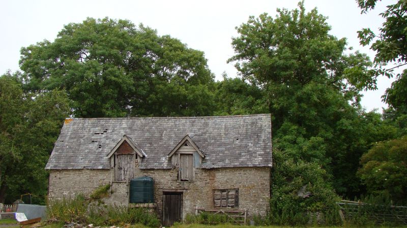
5/7 Stable and granary about
10 yards south-east of
Kintley Farmhouse
GV II
Stable and granary. C17. Rubble and some timber-framing with brick and
wattle-and-daub infill. Slate roof. Three bays. Two levels. Framing:
collar and tie-beam trusses with two collars and struts at gable ends.
South end truss is altered and has subsidiary rails. Main west elevation:
there is a shuttered ground floor opening and two loft doors, one of which is
approached by a flight of external rubble steps. To the right is a door with
a timber lintel. At the south gable is a loft opening and a small, partly
weatherboarded, timber-framed wing of one bay and one storey. (RCHM, III,
p 24, item 5).
Listing NGR: SO2745649819
External links are from the relevant listing authority and, where applicable, Wikidata. Wikidata IDs may be related buildings as well as this specific building. If you want to add or update a link, you will need to do so by editing the Wikidata entry.


Other nearby listed buildings
