Latitude: 53.7456 / 53°44'44"N
Longitude: -0.8683 / 0°52'5"W
OS Eastings: 474730
OS Northings: 428286
OS Grid: SE747282
Mapcode National: GBR QTC4.T1
Mapcode Global: WHFDC.M3QW
Plus Code: 9C5XP4WJ+6M
Entry Name: 3, Saint John's Street
Listing Date: 15 September 1987
Grade: II
Source: Historic England
Source ID: 1083165
English Heritage Legacy ID: 165361
ID on this website: 101083165
Location: Howden, East Riding of Yorkshire, DN14
County: East Riding of Yorkshire
Civil Parish: Howden
Built-Up Area: Howden
Traditional County: Yorkshire
Lieutenancy Area (Ceremonial County): East Riding of Yorkshire
Church of England Parish: Howden with Barmby on the Marsh
Church of England Diocese: York
Tagged with: Building
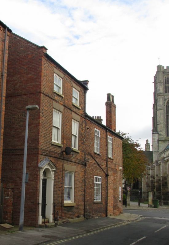
HOWDEN SAINT JOHN'S STREET
SE 7428
(north side)
12/132 No 3
GV II
House. Late C18 with C19 fenestration and C20 restoration. Brick in
Flemish bond, concrete tile roof. 3 storeys, 2 bays. 6-fielded-panel door
with radial fanlight in pilastered doorcase with open pediment on consoles
containing patera. Wide 4-pane sash to right. First floor: band and 4-pane
sashes. Second floor: band and squat 4-pane sashes. Rendered wedge lintels
and stone sills throughout. Dentilled eaves course. Raised gable ends with
brick kneelers. End stacks. Left gable end rebuilt. Interior: closed-
string staircase with slender turned balusters and 6-fielded-panel doors.
Neave D, Howden Explored, 1979.
Listing NGR: SE7473028288
External links are from the relevant listing authority and, where applicable, Wikidata. Wikidata IDs may be related buildings as well as this specific building. If you want to add or update a link, you will need to do so by editing the Wikidata entry.


Other nearby listed buildings