Approximate Location Map
Large Map »
Latitude: 51.1172 / 51°7'1"N
Longitude: 0.4332 / 0°25'59"E
OS Eastings: 570397
OS Northings: 138134
OS Grid: TQ703381
Mapcode National: GBR NRJ.VRW
Mapcode Global: VHJN4.G5CX
Plus Code: 9F324C8M+V7
Entry Name: Mounting Block About 20 Metres North of Church of St Margaret
Listing Date: 10 October 1989
Grade: II
Source: Historic England
Source ID: 1084555
English Heritage Legacy ID: 169857
ID on this website: 101084555
Location: St Margaret's Church, Smallbridge, Tunbridge Wells, Kent, TN12
County: Kent
District: Tunbridge Wells
Civil Parish: Horsmonden
Traditional County: Kent
Lieutenancy Area (Ceremonial County): Kent
Church of England Parish: Horsmonden St Margaret
Church of England Diocese: Rochester
Tagged with: Building
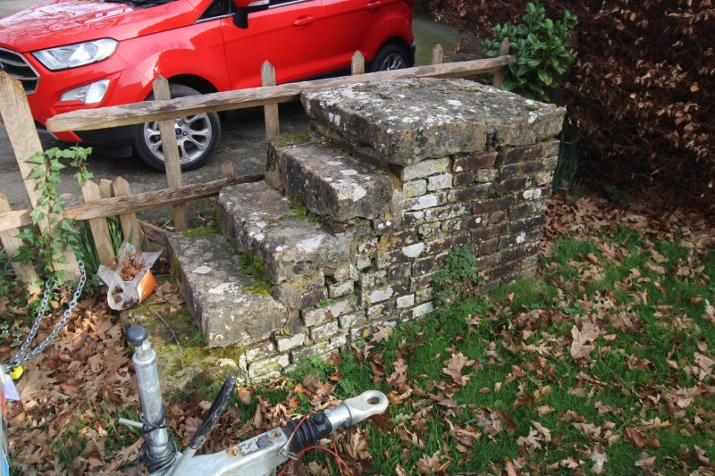
HORSMONDEN BRICK KILN LANE
TQ 73 NW
(south east side)
4/21 Mounting Block about 20
metres north of Church of
St.Margaret
GV II
Mounting Block. C17. Red brick in English Bond with sandstone slab treads and
mounting stone. Simple flight of 4 steps to top slab, about 3 feet in total height.
Listing NGR: TQ7039738134
External links are from the relevant listing authority and, where applicable, Wikidata. Wikidata IDs may be related buildings as well as this specific building. If you want to add or update a link, you will need to do so by editing the Wikidata entry.


Other nearby listed buildings
