Approximate Location Map
Large Map »
Latitude: 51.2817 / 51°16'54"N
Longitude: 1.0842 / 1°5'3"E
OS Eastings: 615185
OS Northings: 158135
OS Grid: TR151581
Mapcode National: GBR TY2.QXJ
Mapcode Global: VHLGM.R11S
Plus Code: 9F3373JM+MM
Entry Name: 89, Broad Street
Listing Date: 7 September 1973
Grade: II
Source: Historic England
Source ID: 1085109
English Heritage Legacy ID: 170441
ID on this website: 101085109
Location: Northgate, Canterbury, Kent, CT1
County: Kent
District: Canterbury
Electoral Ward/Division: Northgate
Parish: Non Civil Parish
Built-Up Area: Canterbury
Traditional County: Kent
Lieutenancy Area (Ceremonial County): Kent
Tagged with: Building
1.
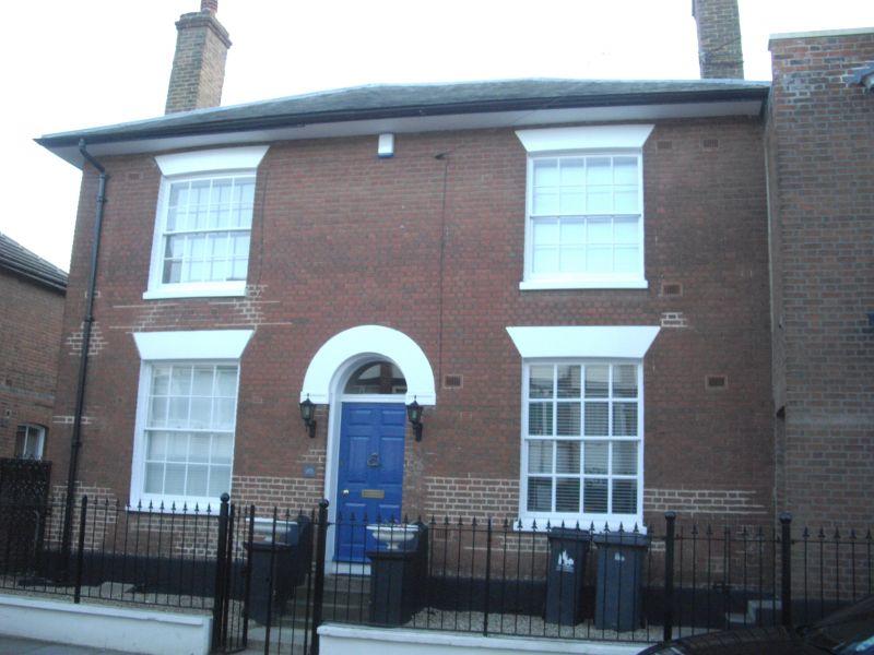
944 BROAD STREET
(South West Side)
No 89
TR 1558 SW 3/442
II GV
2.
Mid C19. 2 storeys-faced with red brick. Buff brick on other elevations.
Hipped slate roof. 2 sashes with glazing bars intact, Ground floor has a
central round-headed doorcase with semi-circular fanlight and 6 panelled
door. Right side extension of 2 storeys red brick with slate roof and 3
light canted bay on 2 floors.
Nos 80 to 89 (consec) form a group.
Listing NGR: TR1518058134
External links are from the relevant listing authority and, where applicable, Wikidata. Wikidata IDs may be related buildings as well as this specific building. If you want to add or update a link, you will need to do so by editing the Wikidata entry.


Other nearby listed buildings
