Approximate Location Map
Large Map »
Latitude: 51.2819 / 51°16'54"N
Longitude: 1.0843 / 1°5'3"E
OS Eastings: 615190
OS Northings: 158161
OS Grid: TR151581
Mapcode National: GBR TY2.JYJ
Mapcode Global: VHLGM.R13L
Plus Code: 9F3373JM+QP
Entry Name: 66-69, Broad Street
Listing Date: 7 September 1973
Grade: II
Source: Historic England
Source ID: 1085147
English Heritage Legacy ID: 170426
ID on this website: 101085147
Location: Northgate, Canterbury, Kent, CT1
County: Kent
District: Canterbury
Electoral Ward/Division: Northgate
Parish: Non Civil Parish
Built-Up Area: Canterbury
Traditional County: Kent
Lieutenancy Area (Ceremonial County): Kent
Tagged with: Building
1.
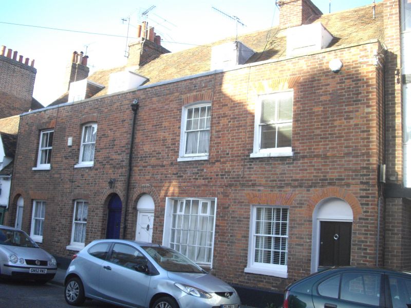
944 BROAD STREET
(North East Side)
Nos 66 to 69 (consec)
TR 1558 SW 3/294
II GV
2.
Early C19 fronts to older buildings. Red brick. Tiled roof with 4 dormers.
4 altered sashes. Rainwater head. Simple round-headed doorcases with blocked
fanlight.
Nos 66 to 79 (consec) form a group.
Listing NGR: TR1519058161
External links are from the relevant listing authority and, where applicable, Wikidata. Wikidata IDs may be related buildings as well as this specific building. If you want to add or update a link, you will need to do so by editing the Wikidata entry.


Other nearby listed buildings
