Approximate Location Map
Large Map »
Latitude: 51.1972 / 51°11'50"N
Longitude: 0.0647 / 0°3'52"E
OS Eastings: 544354
OS Northings: 146249
OS Grid: TQ443462
Mapcode National: GBR LMD.Z0K
Mapcode Global: VHHQ3.25JJ
Plus Code: 9F3253W7+VV
Entry Name: 46 and 48, High Street
Listing Date: 16 January 1975
Grade: II
Source: Historic England
Source ID: 1085946
English Heritage Legacy ID: 357187
ID on this website: 101085946
Location: Edenbridge, Sevenoaks, Kent, TN8
County: Kent
District: Sevenoaks
Civil Parish: Edenbridge
Built-Up Area: Edenbridge
Traditional County: Kent
Lieutenancy Area (Ceremonial County): Kent
Church of England Parish: Edenbridge St Peter and St Paul
Church of England Diocese: Rochester
Tagged with: Building
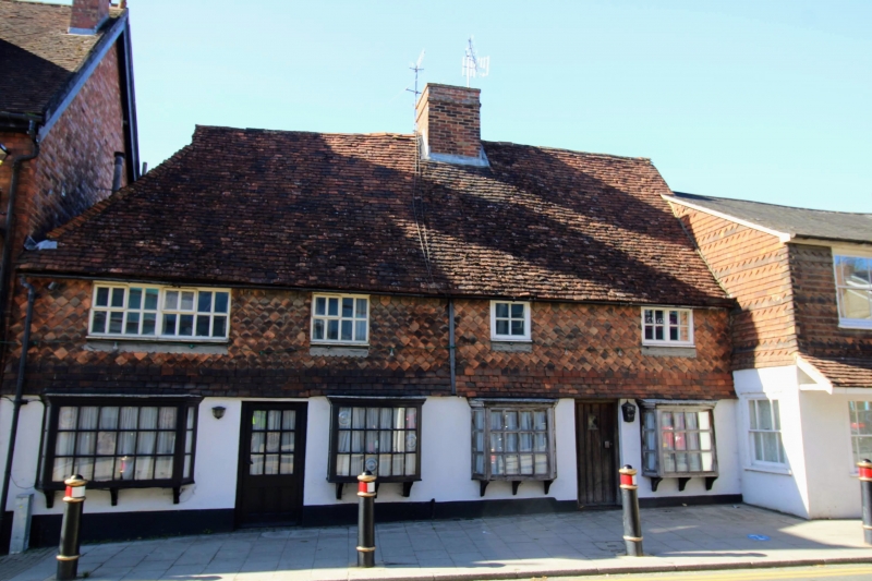
EDENERIDGE EDENERIDGE
1.
5280
High Street
(West Side)
Nos 46 and 48
TQ 4446 12/433
II GV
2.
Cl6 or earlier hall (No 48) with later extension (No 46) probably C17. Now as
pair, each 2 storeys, 2 windows. High pitched tiled roof hipped at left, with
shortened ridge stack. Fancy tile hung 1st floor. Rendered plinth. Various
casement windows, including one C18 leaded iron at lst floor right. No 46 has
plank door. No 48 has modern glazed door flanked by reproduction oriel shop
windows.
Nos 44 to 48 (even) form a group.
Listing NGR: TQ4435446249
External links are from the relevant listing authority and, where applicable, Wikidata. Wikidata IDs may be related buildings as well as this specific building. If you want to add or update a link, you will need to do so by editing the Wikidata entry.


Other nearby listed buildings
