Approximate Location Map
Large Map »
Latitude: 54.2008 / 54°12'2"N
Longitude: -2.9538 / 2°57'13"W
OS Eastings: 337874
OS Northings: 478761
OS Grid: SD378787
Mapcode National: GBR 7MTV.9W
Mapcode Global: WH83C.LNMY
Plus Code: 9C6V622W+8F
Entry Name: Kings Arms Public House
Listing Date: 25 March 1970
Grade: II
Source: Historic England
Source ID: 1087172
English Heritage Legacy ID: 77015
ID on this website: 101087172
Location: Cartmel, Westmorland and Furness, Cumbria, LA11
County: Cumbria
District: South Lakeland
Civil Parish: Lower Allithwaite
Traditional County: Lancashire
Lieutenancy Area (Ceremonial County): Cumbria
Church of England Parish: Cartmel St Mary and St Michael
Church of England Diocese: Carlisle
Tagged with: Pub
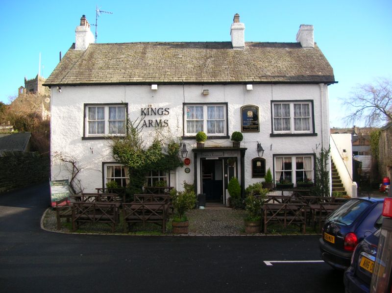
LOWER ALLIThWAITE ' THE SQUARE
SD 3778
(South side) Cartmel
8/101 Kings Arms Public
25.3.70 House
G.V. II
Public House. C18 with later additions. Roughcast stone with slate roof. West
facade of 2 storeys, 3 bays. Windows are sashed; 2 windows to 1st bay of ground
floor (one originally entrance) have vertical glazing bars; those to 3rd bay and
1st floor have paired sashes with single glazing bars. Entrance to 2nd bay is
C20, 6-panel door with side light and large flat canopy on side supports.
Double-sided mounting block. Gable-end stacks and cross-axial stack. 2 gabled
wings to rear. Left return has varied fenestration including paired sash and
window with small-paned fixed glazing and opening light; lateral stack. Rear
has lean-to extension, part projecting over River Eea on posts. Interior has
stop-chamfered beams and ovolo beam.
Listing NGR: SD3787478761
External links are from the relevant listing authority and, where applicable, Wikidata. Wikidata IDs may be related buildings as well as this specific building. If you want to add or update a link, you will need to do so by editing the Wikidata entry.


Other nearby listed buildings
