Approximate Location Map
Large Map »
Latitude: 51.3738 / 51°22'25"N
Longitude: 1.3085 / 1°18'30"E
OS Eastings: 630362
OS Northings: 169059
OS Grid: TR303690
Mapcode National: GBR WZW.TXK
Mapcode Global: VHLG5.MQMP
Plus Code: 9F3398F5+GC
Entry Name: 207, Canterbury Road
Listing Date: 22 February 1973
Grade: II
Source: Historic England
Source ID: 1088985
English Heritage Legacy ID: 356494
ID on this website: 101088985
Location: Birchington, Thanet, Kent, CT7
County: Kent
District: Thanet
Civil Parish: Birchington
Built-Up Area: Margate
Traditional County: Kent
Lieutenancy Area (Ceremonial County): Kent
Tagged with: Building
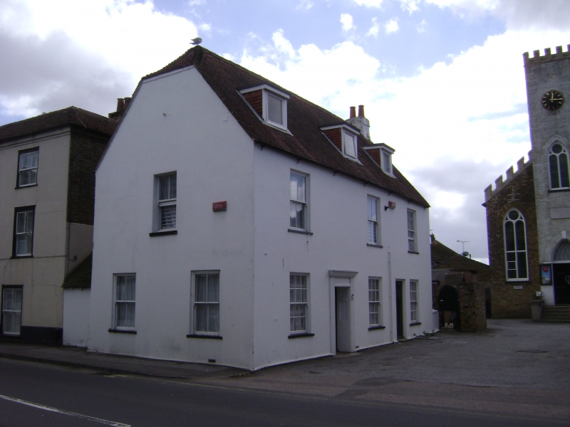
CANTERBURY ROAD
1.
1380
(South Side)
BIRCHINGTON-ON-SEA
No 207
TR 36 NW 9/112
II
2.
C18 altered. 2 storeys plastered with pseudo timber framing. Renewed tiled
half-hipped roof with 3 dormers. 3 altered sashes. Later C19 shopfront to
road elevation. The side elevation has a simple doorcase with semi-hood,
panelled reveals and panelled door.
Listing NGR: TR3036269059
External links are from the relevant listing authority and, where applicable, Wikidata. Wikidata IDs may be related buildings as well as this specific building. If you want to add or update a link, you will need to do so by editing the Wikidata entry.


Other nearby listed buildings
