Approximate Location Map
Large Map »
Latitude: 51.6388 / 51°38'19"N
Longitude: -2.162 / 2°9'43"W
OS Eastings: 388885
OS Northings: 193349
OS Grid: ST888933
Mapcode National: GBR 1P0.66M
Mapcode Global: VH95K.G2WH
Plus Code: 9C3VJRQQ+G6
Entry Name: 58, Long Street
Listing Date: 6 September 1954
Grade: II
Source: Historic England
Source ID: 1089591
English Heritage Legacy ID: 128561
ID on this website: 101089591
Location: Tetbury, Cotswold, Gloucestershire, GL8
County: Gloucestershire
District: Cotswold
Civil Parish: Tetbury
Built-Up Area: Tetbury
Traditional County: Gloucestershire
Lieutenancy Area (Ceremonial County): Gloucestershire
Church of England Parish: Tetbury St Mary the Virgin
Church of England Diocese: Gloucester
Tagged with: Building
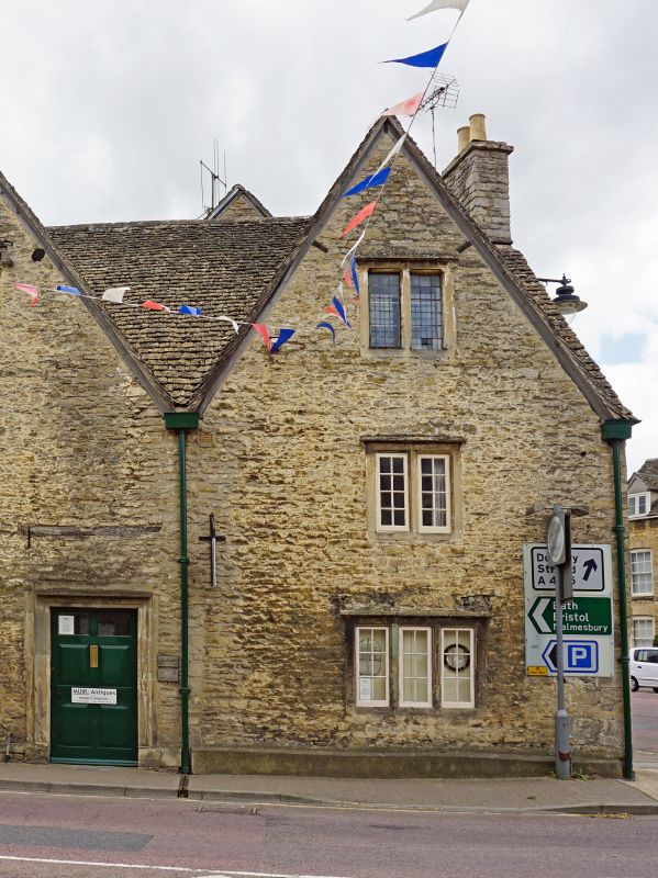
ST 8893-8993 TETBURY LONG STREET
(west side)
7/286 No 58
6.9.54
GV II
Corner house. Late C17/early C18. Rubble stone, Cotswold stone
slate roof, stone stack to right. Large gable to each side of
corner (Long Street and New Church Street). 2 storeys and attic.
One window, 2-light stone mullion with straight dripmould to 1st
and gable. Ground floor has 3-light. Doorway is in No. 56 (q.v.).
Listing NGR: ST8888693347
External links are from the relevant listing authority and, where applicable, Wikidata. Wikidata IDs may be related buildings as well as this specific building. If you want to add or update a link, you will need to do so by editing the Wikidata entry.


Other nearby listed buildings
