Latitude: 51.9149 / 51°54'53"N
Longitude: -2.0487 / 2°2'55"W
OS Eastings: 396747
OS Northings: 224041
OS Grid: SO967240
Mapcode National: GBR 2LZ.YPD
Mapcode Global: VHB1Q.F4SC
Plus Code: 9C3VWX72+XG
Entry Name: Former Stables Circa 35 Metres North of the Prestbury House Hotel and Adjoining Wall
Listing Date: 25 February 1987
Grade: II
Source: Historic England
Source ID: 1091935
English Heritage Legacy ID: 134459
ID on this website: 101091935
Location: Prestbury, Cheltenham, Gloucestershire, GL52
County: Gloucestershire
District: Cheltenham
Civil Parish: Prestbury
Built-Up Area: Cheltenham
Traditional County: Gloucestershire
Lieutenancy Area (Ceremonial County): Gloucestershire
Church of England Parish: Prestbury St Mary
Church of England Diocese: Gloucester
Tagged with: Stable
SO 9624 PRESTBURY THE BURGAGE (east side)
17/54 Former stables c35m north of The Prestbury House Hotel and adjoining wall
GV II
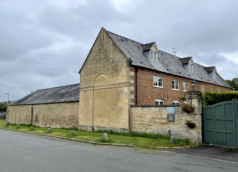
Former stableblock in the grounds of The Prestbury House Hotel. Late C18-early C19. Flemish bond brick. Gable end to road ashlar. Slate roof. Rectangular plan to former stableblock with wall including entrance-way running away to right of gable end to road. Single storey stone building to left of gable end not of special interest. Stables; 2 storeys and attic lit by three 2-light roof dormers. Four segmental-headed cross windows. Two double plank doors one with glazing over. Two single plank doors within segmental-headed surrounds. One blocked single width doorway. Brick dentil cornice. Blind round-headed archway in gable end to road with continuous band at impost level. Saddleback coping with moulded kneelers with ball finials at gable ends. Wall; coursed squared and dressed limestone. Wall runs for c13m as far as subsidiary pier marking point where wall has been reduced in height. Height c2.5m. Entrance flanked by square piers, double bands towards the top of each pier and pyramidal cappings. C20 lanterns at the apex of each. Early plank door with decorative strap hinges to right of the entrance. Wall ramped down to subsidiary pier matching those flanking the entrance.
Listing NGR: SO9674724041
External links are from the relevant listing authority and, where applicable, Wikidata. Wikidata IDs may be related buildings as well as this specific building. If you want to add or update a link, you will need to do so by editing the Wikidata entry.


Other nearby listed buildings