Approximate Location Map
Large Map »
Latitude: 51.3439 / 51°20'37"N
Longitude: 0.3697 / 0°22'11"E
OS Eastings: 565141
OS Northings: 163196
OS Grid: TQ651631
Mapcode National: GBR NNQ.Q9C
Mapcode Global: VHJLY.CHB4
Plus Code: 9F3289V9+GV
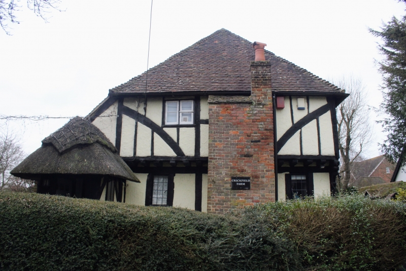
Entry Name: Crickfield Farmhouse
Listing Date: 21 November 1966
Grade: II
Source: Historic England
Source ID: 1096347
English Heritage Legacy ID: 356803
ID on this website: 101096347
Location: Harvel, Gravesham, Kent, DA13
County: Kent
District: Gravesham
Civil Parish: Meopham
Traditional County: Kent
Lieutenancy Area (Ceremonial County): Kent
Church of England Parish: Meopham St John the Baptist
Church of England Diocese: Rochester
Tagged with: Farmhouse
TQ 66 SE MEOPHAM HARVEL STREET
8/74
21.11.66 Crickfield Farmhouse
II
Late C15 timber-framed "hall" house with plaster panels and curved braces on first
floor. Brick nogging on ground floor. First floor lettied on north-east front.
Hipped tiled roof. Casement windows. Two modern porches. Moulded timber beams and
remains of screen with shaped heads to openings internally.
Listing NGR: TQ6514163196
External links are from the relevant listing authority and, where applicable, Wikidata. Wikidata IDs may be related buildings as well as this specific building. If you want to add or update a link, you will need to do so by editing the Wikidata entry.


Other nearby listed buildings
