Latitude: 52.2429 / 52°14'34"N
Longitude: 0.7129 / 0°42'46"E
OS Eastings: 585318
OS Northings: 263996
OS Grid: TL853639
Mapcode National: GBR QF0.732
Mapcode Global: VHKD4.9WRF
Plus Code: 9F426PV7+55
Entry Name: Masongill House
Listing Date: 12 July 1972
Grade: II
Source: Historic England
Source ID: 1096717
English Heritage Legacy ID: 467822
ID on this website: 101096717
Location: Bury St Edmunds, West Suffolk, IP33
County: Suffolk
District: West Suffolk
Civil Parish: Bury St Edmunds
Built-Up Area: Bury St Edmunds
Traditional County: Suffolk
Lieutenancy Area (Ceremonial County): Suffolk
Church of England Parish: Bury St Edmunds St Mary
Church of England Diocese: St.Edmundsbury and Ipswich
Tagged with: House
BURY ST EDMUNDS
TL8563NW WHITING STREET
639-1/15/723 (West side)
12/07/72 No.69
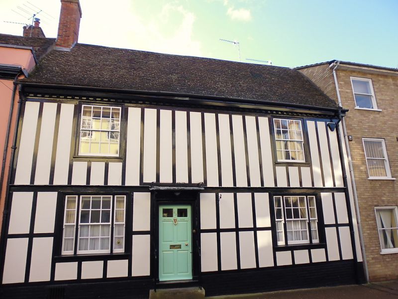
Masongill House
GV II
House. C15 and C16 with later fronting. Timber-framed and
rendered with applied mock timbering. Plaintiled roof with a
modillion eaves cornice.
EXTERIOR: 2 storeys and cellar: 2 wings at rear. 2 windows to
each storey: 16-pane sashes to the 1st storey, tripartite
sashes with 12-pane central windows to the ground storey, all
in flush cased frames. A 6-panel entrance door with the top 4
panels glazed has a moulded architrave and a shallow hood on
shaped brackets. It is approached by steps with iron
handrails, and surrounded by a C20 cast-iron openwork porch.
INTERIOR: brick-lined cellar. Front range in 2 long bays. The
room on the left of the entry has some exposed studding on the
rear wall and a fireplace on the south side wall. A cast-iron
C19 grate has a row of C17 blue Dutch tiles above. The room to
the right has a main beam which has been adzed back and
chamfered flat joists with step stops.
A chimney-stack on the rear wall has an open fireplace with a
plain timber lintel and old brickwork rebuilt. Part of the
upper stack is in flint. The north rear wing is in 2 bays,
originally forming a single room on each storey, but now with
partitioning. The fireplace on the west side of the internal
chimney-stack has a very large plain cambered lintel with
supporting stone jambs in an altered position.
On the upper storey, the north wall has exposed studding and
very heavy tension bracing. The cambered tie-beam of the
former open truss has a peg-hole for a crown-post, but the
roof above is a complete C20 replacement. The base and part of
the shaft of the crown-post remain in the house, the shaft
octagonal with curved stops to the base. The south wing abuts
on the rear wing of No.68 (qv). The roof over the front range
was reconstructed in the C19; it incorporates a number of
earlier rafters, including some with smoke blackening from the
roof of an open hall, possibly from an earlier form of the
present house.
Listing NGR: TL8531863996
External links are from the relevant listing authority and, where applicable, Wikidata. Wikidata IDs may be related buildings as well as this specific building. If you want to add or update a link, you will need to do so by editing the Wikidata entry.


Other nearby listed buildings