Approximate Location Map
Large Map »
Latitude: 52.2411 / 52°14'27"N
Longitude: 0.7135 / 0°42'48"E
OS Eastings: 585367
OS Northings: 263791
OS Grid: TL853637
Mapcode National: GBR QF0.F71
Mapcode Global: VHKD4.BX2V
Plus Code: 9F426PR7+CC
Entry Name: Rose and Crown Public House
Listing Date: 12 July 1972
Grade: II
Source: Historic England
Source ID: 1096769
English Heritage Legacy ID: 467780
ID on this website: 101096769
Location: Bury St Edmunds, West Suffolk, IP33
County: Suffolk
District: West Suffolk
Civil Parish: Bury St Edmunds
Built-Up Area: Bury St Edmunds
Traditional County: Suffolk
Lieutenancy Area (Ceremonial County): Suffolk
Church of England Parish: Bury St Edmunds St Mary
Church of England Diocese: St.Edmundsbury and Ipswich
Tagged with: Pub
BURY ST EDMUNDS
TL8563NW WHITING STREET
639-1/15/709 (East side)
12/07/72 No.48
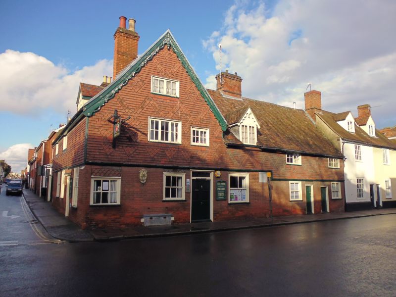
Rose and Crown Public House
GV II
Includes: Nos.50, 51 AND 52 Rose and Crown Public House
WESTGATE STREET.
Public house. C17 with C19 exterior and probably C15 core.
Timber-framed, encased in C19 red brick on the ground storey
and faced in alternate bands of plain and ornamental tiles on
the upper storey. Plaintiled roofs.
EXTERIOR: part 2 storeys, part 2 storeys and attics; cellar to
part. On a corner site with a return front to Westgate Street.
In 2 ranges: a wide gable at the south-east corner has fluted
bargeboards and a hanging finial.
Random fenestration: various sash windows to the ground
storey, those on the Whiting Street frontage 12-pane; all in
flush cased frames. Various small-paned casement windows to
the upper storey. One gabled dormer facing Whiting Street and
one facing Westgate Street with fluted barge boards and ornate
ridge tiles: both have small-paned 2-light casement windows. 4
doors: that on Whiting Street with a plain wood surround and
flat pediment.
INTERIOR: a small completely modernised cellar below the
Whiting Street range. No.52 Westgate Street is a separate
derelict one bay cottage with a section of plain unchamfered
flat C16 joists and one main beam exposed on the ground storey
and some rafters visible above: clasped purlin roof.
The remainder of the Westgate range has clear indications of
heightening in the C17, with the remains of joists and one
tie-beam at a lower level. Evidence that the whole frame has
been raised continues into the Whiting Street range, where the
lower original wallplate is visible and main posts have had
tie-beams removed. Later main posts have jowled heads and the
remains of long arched braces.
On the ground storey of the Whiting Street range the main
beams are very heavy, some encased. Roofs inaccessible. Too
little of the framing is exposed for any clear analysis, but
each range may have contained an open hall initially.
Listing NGR: TL8536763791
External links are from the relevant listing authority and, where applicable, Wikidata. Wikidata IDs may be related buildings as well as this specific building. If you want to add or update a link, you will need to do so by editing the Wikidata entry.


Other nearby listed buildings
