Approximate Location Map
Large Map »
Latitude: 52.2412 / 52°14'28"N
Longitude: 0.7132 / 0°42'47"E
OS Eastings: 585346
OS Northings: 263807
OS Grid: TL853638
Mapcode National: GBR QF0.F4S
Mapcode Global: VHKD4.9XXR
Plus Code: 9F426PR7+F7
Entry Name: 54 and 55, Whiting Street
Listing Date: 12 July 1972
Grade: II
Source: Historic England
Source ID: 1096772
English Heritage Legacy ID: 467783
ID on this website: 101096772
Location: Bury St Edmunds, West Suffolk, IP33
County: Suffolk
District: West Suffolk
Civil Parish: Bury St Edmunds
Built-Up Area: Bury St Edmunds
Traditional County: Suffolk
Lieutenancy Area (Ceremonial County): Suffolk
Church of England Parish: Bury St Edmunds St Mary
Church of England Diocese: St.Edmundsbury and Ipswich
Tagged with: Building
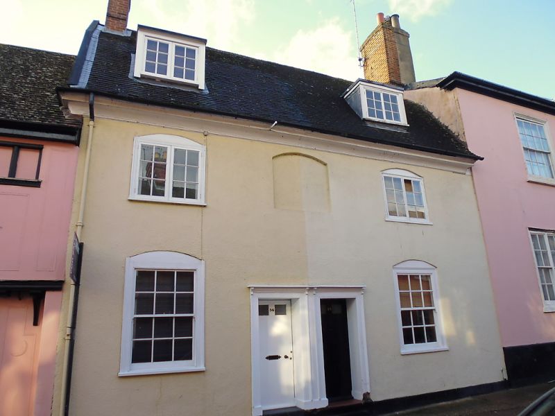
BURY ST EDMUNDS
TL8563NW WHITING STREET
639-1/15/712 (West side)
12/07/72 Nos.54 AND 55
GV II
House, now divided into 2. C18. Timber-framed and rendered;
plaintiled roof with a wide eaves overhang and plain wood
soffit. 2 gable end chimney-stacks with tall plain red brick
shafts.
EXTERIOR: 2 storeys and attics; 2 window range: 2-light
small-paned casements to the upper storey with
segmental-arched surrounds with a blank panel of similar form
between them; 12-pane sashes with segmental-arched surrounds
to the ground storey in flush cased frames. 2 flat-headed
dormers with small-paned casement windows. Paired recessed
central doors in plain wood reveals and architraves have a
shallow hood with small brackets. A pantiled single storey
lean-to along the rear has been partly raised. The rear wall
of the house is in red brick.
INTERIOR: no timbers exposed inside No.55. Both storeys have
boxed-in main beams. Large attic storey. A winder stair in the
rear corner.
Listing NGR: TL8534663807
External links are from the relevant listing authority and, where applicable, Wikidata. Wikidata IDs may be related buildings as well as this specific building. If you want to add or update a link, you will need to do so by editing the Wikidata entry.


Other nearby listed buildings
