Latitude: 52.3652 / 52°21'54"N
Longitude: -1.9104 / 1°54'37"W
OS Eastings: 406197
OS Northings: 274132
OS Grid: SP061741
Mapcode National: GBR 3H2.PTV
Mapcode Global: VH9ZG.TTX6
Plus Code: 9C4W938Q+3R
Entry Name: Hall Farmhouse
Listing Date: 16 July 1986
Grade: II
Source: Historic England
Source ID: 1100137
English Heritage Legacy ID: 156259
ID on this website: 101100137
Location: Weatheroak Hill, Bromsgrove, Worcestershire, B48
County: Worcestershire
District: Bromsgrove
Civil Parish: Wythall
Traditional County: Worcestershire
Lieutenancy Area (Ceremonial County): Worcestershire
Church of England Parish: Wythall
Church of England Diocese: Birmingham
Tagged with: Farmhouse
SP 07 SE WYTHALL CP HILL LANE (north side)
Weatheroak Hill
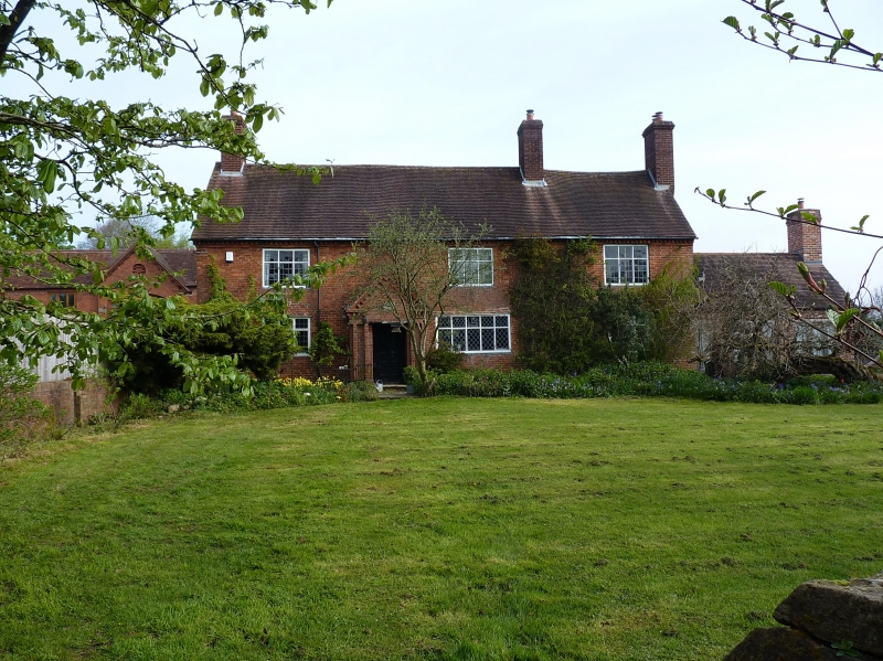
7/207 Hall Farmhouse
GV II
Farmhouse. C16, clad in 1827, extended 1895. Timber-frame clad in brick
with tile roof. South front: two storeys with dentilled brick cornice,
three windows: 3-light casements; ground floor: entrance to left of centre
has C20 gabled brick porch with panelled door. Interior: central room has
chamfered ceiling beams with evidence for jetty to front. Window of this
room contains some re-set C15 stained glass. In the roof there is a panelled
room without windows, which may have been a secret Roman Catholic chapel.
Datestones set in porch gable. (Granville Squiers, Secret Hiding Places,
1933, pp 70-71).
Listing NGR: SP0619774132
External links are from the relevant listing authority and, where applicable, Wikidata. Wikidata IDs may be related buildings as well as this specific building. If you want to add or update a link, you will need to do so by editing the Wikidata entry.


Other nearby listed buildings