Latitude: 52.3643 / 52°21'51"N
Longitude: -1.919 / 1°55'8"W
OS Eastings: 405614
OS Northings: 274030
OS Grid: SP056740
Mapcode National: GBR 3H2.MNP
Mapcode Global: VH9ZG.PTCX
Plus Code: 9C4W937J+PC
Entry Name: Weatheroak Farmhouse
Listing Date: 23 April 1952
Last Amended: 16 July 1986
Grade: II
Source: Historic England
Source ID: 1348535
English Heritage Legacy ID: 156073
ID on this website: 101348535
Location: Weatheroak Hill, Bromsgrove, Worcestershire, B48
County: Worcestershire
District: Bromsgrove
Civil Parish: Alvechurch
Traditional County: Worcestershire
Lieutenancy Area (Ceremonial County): Worcestershire
Church of England Parish: Wythall
Church of England Diocese: Birmingham
Tagged with: Farmhouse
SP 07 SE ALVECHURCH CP RADFORD ROAD (south side)
Weatheroak Hill
7/20 Weatheroak Farmhouse
(formerly listed as
23.4.52 Weatheroak Hill Farmhouse)
GV II
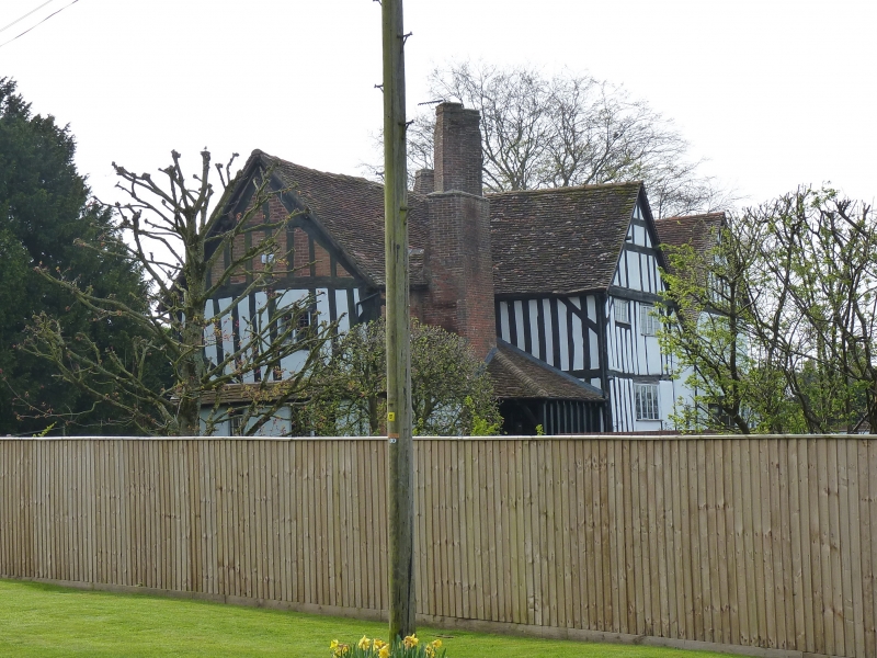
Farmhouse. Late C16, early C17 and late C17 incorporating a fragment of
an open hall house. Timber-frame with rendered infill and probably rendered
sandstone. Plan is complex, single bay to north end late C16, next bay early
C17, south cross-wing and bay in line with rest late C17, stack in latter bay
has three diamond shafts. East front: two storeys with gabled cross-wing to
left (probably rendered sandstone), four windows: mostly 3-light C20 casements;
ground floor: canted bay window with lean-to roof, then three windows of two,
five and three lights; roughly central a C20 gabled porch with 3-light casement
to front, replacing a two-storey timber-framed porch. Framing: herringbone to
first floor, slightly jettied over close-studded ground floor; gable of cross-
wing has two collars and ornamental bracing. Interior: against the north face
of the main stack are the remnants of a truss with two struts and collar with
extensive smoke-blackening.
Listing NGR: SP0561474030
External links are from the relevant listing authority and, where applicable, Wikidata. Wikidata IDs may be related buildings as well as this specific building. If you want to add or update a link, you will need to do so by editing the Wikidata entry.


Other nearby listed buildings