Latitude: 52.3677 / 52°22'3"N
Longitude: -1.9104 / 1°54'37"W
OS Eastings: 406195
OS Northings: 274405
OS Grid: SP061744
Mapcode National: GBR 3H2.HV2
Mapcode Global: VH9ZG.TRW9
Plus Code: 9C4W939Q+3R
Entry Name: Weatheroak Hall, Kings Norton Golf Club
Listing Date: 23 April 1952
Last Amended: 16 July 1986
Grade: II
Source: Historic England
Source ID: 1348590
English Heritage Legacy ID: 156247
ID on this website: 101348590
Location: Weatheroak Hall, Weatheroak Hill, Bromsgrove, Worcestershire, B48
County: Worcestershire
District: Bromsgrove
Civil Parish: Wythall
Traditional County: Worcestershire
Lieutenancy Area (Ceremonial County): Worcestershire
Church of England Parish: Wythall
Church of England Diocese: Birmingham
Tagged with: Architectural structure
SP 07 SE WYTHALL CP BROCKHILL LANE (east side) Weatheroak Hill
7/195 Weatheroak Hall, Kings Norton Golf Club 23.4.52 (Formerly listed as Weatheroak Hall)
- II
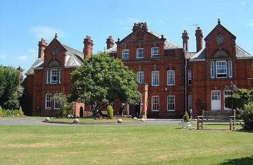
Small country house, now golf club. Late C18 for James Mynors, rebuilt 1884-5 by J Cotton, and late C20 extension set back to right. Brick with stone dressings and tile roof. West front: E-plan, identical projecting wings of two storeys with attic, moulded stone string framed by Corinthian stone pilasters, Venetian window with shell in semi-circular arch, gables above have vertically set oval windows with moulded cornice above; ground floor: pair of sashes, upper half 6-pane, lower three vertical panes; main range of two storeys with attic lit by three sashes in pedimented central feature bearing arms flanked by engaged balusters; below is a moulded stone cornice, 1 + 5 + 1 windows, the centre slightly advanced, all with cambered heads and scrolled pediments; ground floor: central porch has datestone over semi-circular arch with two-leaf door. The C19 plans show that the C18 house remains within the C19 shell. (Peter Reid, Burke's and Savill's Guide to Country Houses, Volume II, Herefordshire, Shropshire, Warwickshire, Worcester- shire, 1980, p 230; plans at Birmingham City Reference Library, Archives Department: Building Plans, Kings Norton Rural District, no 678).
Listing NGR: SP0619574405
External links are from the relevant listing authority and, where applicable, Wikidata. Wikidata IDs may be related buildings as well as this specific building. If you want to add or update a link, you will need to do so by editing the Wikidata entry.


Other nearby listed buildings