Approximate Location Map
Large Map »
Latitude: 51.8951 / 51°53'42"N
Longitude: -2.0669 / 2°4'1"W
OS Eastings: 395489
OS Northings: 221840
OS Grid: SO954218
Mapcode National: GBR 2MC.08H
Mapcode Global: VHB1Q.4M4L
Plus Code: 9C3VVWWM+26
Entry Name: Sandford Park House
Listing Date: 12 March 1955
Last Amended: 26 November 1998
Grade: II
Source: Historic England
Source ID: 1103818
English Heritage Legacy ID: 474894
ID on this website: 101103818
Location: Coltham Fields, Cheltenham, Gloucestershire, GL52
County: Gloucestershire
District: Cheltenham
Electoral Ward/Division: Charlton Park
Parish: Non Civil Parish
Built-Up Area: Cheltenham
Traditional County: Gloucestershire
Lieutenancy Area (Ceremonial County): Gloucestershire
Church of England Parish: Cheltenham St Luke and St John
Church of England Diocese: Gloucester
Tagged with: House
CHELTENHAM
SO9521NW LONDON ROAD
630-1/19/479 (South side)
12/03/55 Nos.39 AND 41
Sandford Park House
(Formerly Listed as:
LONDON ROAD
(South side)
Nos.39 AND 41
Sirsa House (No.39) and Horton House
(No.41))
GV II
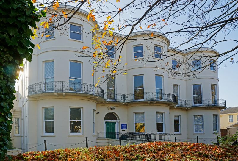
Probably originally 2 houses, now offices. c1820-30. Stucco
over brick with concealed roof and iron balcony and rear
porch.
EXTERIOR: 3 storeys on basement, 11 first-floor windows
arranged 3:1:3:1:3 (including three 3-window full-height
bows); service ranges to rear. Second-floor band, crowning
frieze and cornice with blocking course. 1/1 sashes throughout
in plain reveals and with sills. Off-centre left entrance,
6-panel double doors with Doric columns in antis, frieze and
wide fanlight. Rear: entrance has tent porch on web-motif
brackets.
INTERIOR: includes entrance hall at left with fluted frieze
and dentil cornice; narrow open-well staircase with stick
balusters and panels of scroll and quatrefoil ornament,
wreathed handrail; carved tread ends. Otherwise not inspected.
SUBSIDIARY FEATURES: first-floor continuous balustrade has
embellished rod motif with scroll panels and lattice frieze.
Right return has set-back former Doric porch with pulvinated
frieze and dentil cornice, now with sash windows.
HISTORICAL NOTE: Chatwin notes railings with urn finials
stamped RE and C Marshall, now missing. Shown on Merrett's Map
of 1834 as Keynsham Place.
(Chatwin A: Cheltenham's Ornamental Ironwork: Cheltenham:
1975-1984: 72; Merrett HS: Plan of the Town of Cheltenham:
1834-).
Listing NGR: SO9550021830
External links are from the relevant listing authority and, where applicable, Wikidata. Wikidata IDs may be related buildings as well as this specific building. If you want to add or update a link, you will need to do so by editing the Wikidata entry.


Other nearby listed buildings
