Latitude: 51.8947 / 51°53'40"N
Longitude: -2.0663 / 2°3'58"W
OS Eastings: 395535
OS Northings: 221794
OS Grid: SO955217
Mapcode National: GBR 2MC.0G4
Mapcode Global: VHB1Q.4MHX
Plus Code: 9C3VVWVM+VF
Entry Name: Elm Villa
Listing Date: 14 December 1983
Grade: II
Source: Historic England
Source ID: 1103825
English Heritage Legacy ID: 474901
ID on this website: 101103825
Location: Coltham Fields, Cheltenham, Gloucestershire, GL52
County: Gloucestershire
District: Cheltenham
Electoral Ward/Division: Charlton Park
Parish: Non Civil Parish
Built-Up Area: Cheltenham
Traditional County: Gloucestershire
Lieutenancy Area (Ceremonial County): Gloucestershire
Church of England Parish: Cheltenham St Luke and St John
Church of England Diocese: Gloucester
Tagged with: Building
CHELTENHAM
SO9521NE LONDON ROAD 630-1/20/484 (South side) 14/12/83 No.49 Elm Villa
GV II
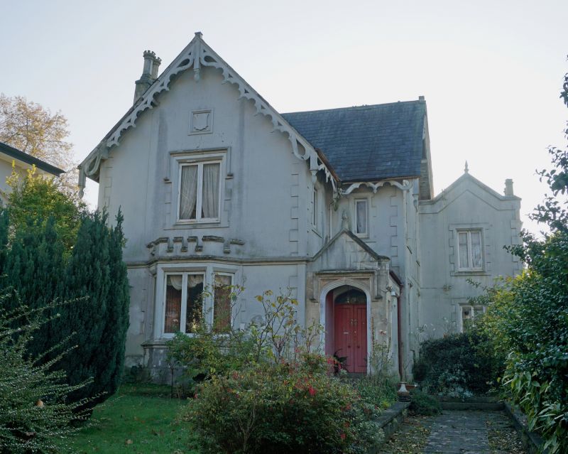
Villa. c1836-75. Stucco over brick with slate roof and end stucco stacks. L-shaped on plan with 2 further stepped bays set back at right. Tudor Gothic style. EXTERIOR: 2 storeys, 3 first-floor windows altogether (1:1:1). Gabled range at left projects, then narrow set-back bay with projecting single-storey porch and further single-storey gabled bay set back at right. Quoins to angles and windows; moulded first-floor band; dripmould over left first-floor window. Left range has ground-floor castellated canted bay. Casement windows. Entrance porch has 4-centred arch and dripmould; within are panelled double doors in 4-centred surround. Porch has gable and copings. Decorative barge-boards except to right which has band to gables and copings with finial to apex. INTERIOR: not inspected.
Listing NGR: SO9552821793
External links are from the relevant listing authority and, where applicable, Wikidata. Wikidata IDs may be related buildings as well as this specific building. If you want to add or update a link, you will need to do so by editing the Wikidata entry.


Other nearby listed buildings