Approximate Location Map
Large Map »
Latitude: 50.6923 / 50°41'32"N
Longitude: -3.138 / 3°8'16"W
OS Eastings: 319714
OS Northings: 88690
OS Grid: SY197886
Mapcode National: GBR PC.6XZY
Mapcode Global: FRA 4797.Z5K
Plus Code: 9C2RMVR6+WQ
Entry Name: The Forge
Listing Date: 22 February 1955
Last Amended: 8 March 1988
Grade: II
Source: Historic England
Source ID: 1104145
English Heritage Legacy ID: 88714
ID on this website: 101104145
Location: Branscombe, East Devon, EX12
County: Devon
District: East Devon
Civil Parish: Branscombe
Traditional County: Devon
Lieutenancy Area (Ceremonial County): Devon
Church of England Parish: Branscombe St Winifred
Church of England Diocese: Exeter
Tagged with: Smithy Thatched building
SY 18 NE BRANSCOMBE BRIDGE
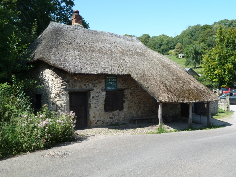
7/42 The Forge (formerly listed as
Smitn's Shop at Margels Bridge)
22.2.55
II
GV
Working forge. Late C18-early C19. Exposed stone rubble; thatch roof.
Plan: forge with open-fronted shelter in front facing onto the road to the east.
It is single storey with a former woodshed adjoining to right.
Exterior: the front contains 2 doorways each with a window to right. The unglazed
windows are shuttered externally. The left door contains a replacement 2-flap plank
door, the right one is blocked. The present main doorway is in the right end from
the former woodshed. The roof is half-hipped to right and hipped to left and
carried down over the woodshed.
Interior is open to the roof of the late C18 - early C19 A-frame trusses. A C19
forge is still in use.
Listing NGR: SY1971688692
External links are from the relevant listing authority and, where applicable, Wikidata. Wikidata IDs may be related buildings as well as this specific building. If you want to add or update a link, you will need to do so by editing the Wikidata entry.


Other nearby listed buildings
