Latitude: 51.8971 / 51°53'49"N
Longitude: -2.0704 / 2°4'13"W
OS Eastings: 395253
OS Northings: 222060
OS Grid: SO952220
Mapcode National: GBR 2MB.5C3
Mapcode Global: VHB1Q.2LB2
Plus Code: 9C3VVWWH+RR
Entry Name: Numbers 32 34 and 36 and Attached Railings
Listing Date: 14 December 1983
Grade: II
Source: Historic England
Source ID: 1104345
English Heritage Legacy ID: 474750
ID on this website: 101104345
Location: Coltham Fields, Cheltenham, Gloucestershire, GL50
County: Gloucestershire
District: Cheltenham
Electoral Ward/Division: All Saints
Parish: Non Civil Parish
Built-Up Area: Cheltenham
Traditional County: Gloucestershire
Lieutenancy Area (Ceremonial County): Gloucestershire
Church of England Parish: Cheltenham St Luke and St John
Church of England Diocese: Gloucester
Tagged with: Building
CHELTENHAM
SO9522SW HIGH STREET 630-1/14/400 (South West side) 14/12/83 Nos.32, 34 AND 36 and attached railings
GV II
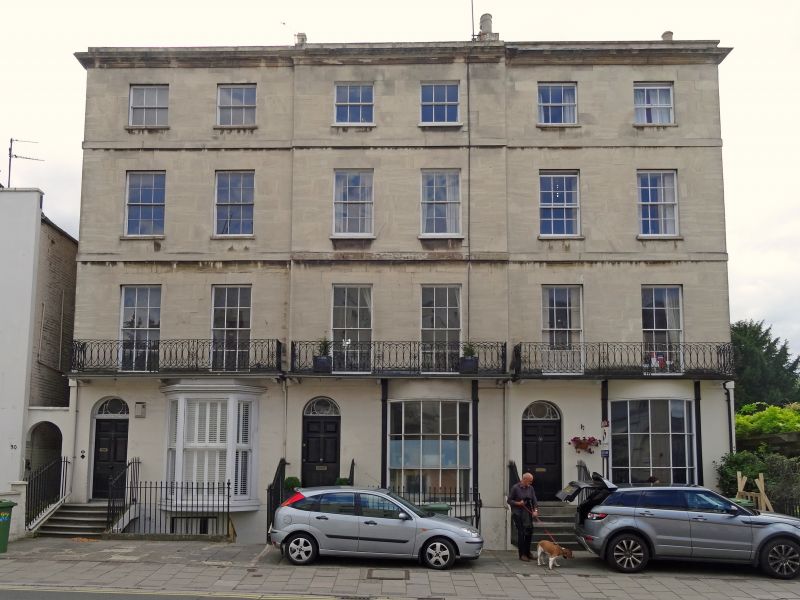
Terrace of 3 houses and attached railings. c1810-20, shown on the Post Office Map of 1820, with later alterations. Ashlar over brick with concealed roof and wrought-iron verandah and iron area railings. EXTERIOR: 4 storeys with basement, 6 first-floor windows (2 per house). Central 2-window range breaks forward. First- and second-floor bands, cornice and blocking course. First- and second-floors have 6/6 sashes, taller to first floor; second floor has 3/3 sashes; basement has 3/3 sashes; all in plain reveals and with sills. Ground floor: canted bay to left has 1/1 sashes, cornice and blocking course; otherwise 2 bow windows. Entrances: flights of steps (roll-edged where original) to 6-panel doors with lattice frieze and fanlights with decorative glazing bars in plain reveals. INTERIOR: not inspected. SUBSIDIARY FEATURES: lancet area railings and to sides of steps and urn finials to stanchions. Verandah has interlaced rod and circle motif. HISTORICAL NOTE: addressed on Merrett's 1834 Map as Southampton Place. A small but early Cheltenham terrace, notable for the two well-preserved bowed shop fronts. (Chatwin A: Cheltenham's Ornamental Ironwork: Cheltenham: 1975-1984: 27; Post Office Map: Cheltenham: 1820-; Merrett HS: Plan of the Town of Cheltenham: 1834-).
Listing NGR: SO9524822063
External links are from the relevant listing authority and, where applicable, Wikidata. Wikidata IDs may be related buildings as well as this specific building. If you want to add or update a link, you will need to do so by editing the Wikidata entry.


Other nearby listed buildings