Latitude: 51.8967 / 51°53'48"N
Longitude: -2.0699 / 2°4'11"W
OS Eastings: 395287
OS Northings: 222022
OS Grid: SO952220
Mapcode National: GBR 2MB.5HM
Mapcode Global: VHB1Q.2LLB
Plus Code: 9C3VVWWJ+M2
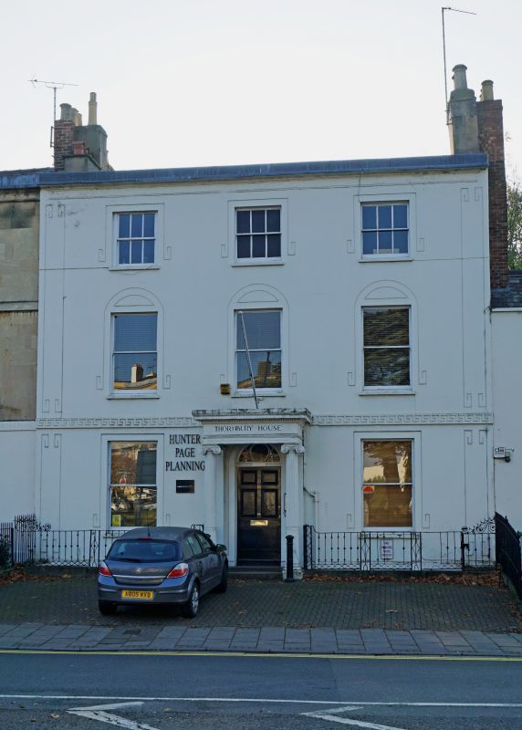
Entry Name: Thornbury House and Attached Railings Belle Vue Place
Listing Date: 12 March 1955
Last Amended: 26 November 1998
Grade: II
Source: Historic England
Source ID: 1333224
English Heritage Legacy ID: 474740
ID on this website: 101333224
Location: Coltham Fields, Cheltenham, Gloucestershire, GL50
County: Gloucestershire
District: Cheltenham
Electoral Ward/Division: College
Parish: Non Civil Parish
Built-Up Area: Cheltenham
Traditional County: Gloucestershire
Lieutenancy Area (Ceremonial County): Gloucestershire
Church of England Parish: Cheltenham St Luke and St John
Church of England Diocese: Gloucester
Tagged with: Architectural structure
CHELTENHAM
SO9522SW HIGH STREET 630-1/14/392 (South West side) 12/03/55 No.18 Thornbury House and attached railings, Belle Vue Place (Formerly Listed as: HIGH STREET (South West side) No.18 Thornbury House)
GV II
House and attached railings. c1810-20, shown on the Post Office Map of 1820. Stucco over brick with slate roof, end stucco stacks and iron railings. EXTERIOR: 3 storeys with basement and attics to rear, 3 first-floor windows. First-floor band with Greek key motif. First floor has incised 'Greek key' motif forming pilaster strips to ends. Ground and first floors have 1/1 sashes; second floor has 3/3 sashes, all in plain reveals and with sills; incised elongated 'Greek key' motif around windows incorporating, to first-floor windows. a segmental arch. Cornice and blocking course. Central entrance a 6-panel door with fanlight with decorative glazing bars within distyle Ionic porch with frieze, architrace and cornice with blocking course. INTERIOR: not inspected. SUBSIDIARY FEATURES: area railings have embellished rods and lozenge panels; railings to right have flattened spearheads and urn finials. HISTORICAL NOTE: Addressed on Merrett's 1834 Map as Belle Vue Place.
Listing NGR: SO9528622020
External links are from the relevant listing authority and, where applicable, Wikidata. Wikidata IDs may be related buildings as well as this specific building. If you want to add or update a link, you will need to do so by editing the Wikidata entry.


Other nearby listed buildings