Approximate Location Map
Large Map »
Latitude: 50.9203 / 50°55'12"N
Longitude: -3.3761 / 3°22'33"W
OS Eastings: 303370
OS Northings: 114324
OS Grid: ST033143
Mapcode National: GBR LN.QBJ3
Mapcode Global: FRA 36TN.VZQ
Plus Code: 9C2RWJCF+4H
Entry Name: Turberfield
Listing Date: 17 March 1988
Grade: II
Source: Historic England
Source ID: 1106396
English Heritage Legacy ID: 96002
ID on this website: 101106396
Location: Sampford Peverell, Mid Devon, EX16
County: Devon
District: Mid Devon
Civil Parish: Sampford Peverell
Built-Up Area: Sampford Peverell
Traditional County: Devon
Lieutenancy Area (Ceremonial County): Devon
Church of England Parish: Sampford Peverell
Church of England Diocese: Exeter
Tagged with: Building
SAMPFORD PEVERELL LOWER TOWN (south side)
ST 01 SW
Sampford Peverell
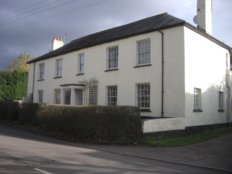
8/153 No.35, Turberfield
-
- II
House. Early - mid C19. Plastered stone rubble; stone rubble stacks with plastered
brick chimneyshafts; slate roof.
Plan: l-shaped house. The main block faces north and is set back a short distance
from the road. It has a 3-room plan, 2 to the left and 1 to the right of the
central entrance hall which also contains the main stair. The outer rooms have end
stacks and the third room has a rear lateral stack. A lower service block projects
at right angles to rear of the right (west) end. It has a 2-room plan with an axial
stack between. 2 storeys.
Exterior: symmetrical 5-window front, all 16-pane sashes except the 12-pane sash in
the middle at first floor level above the front doorway which contains a 6-panel
door, fanlight, panelled reveals and flat-roofed timber porch with panelled square
section posts and plain entablature. Roof is hipped each end. Rear block contains
C19 and C20 casements, most with glazing bars; the oldest is at first floor level on
the outer (western) side; it contains rectangular panes of leaded glass.
Interior: not inspected but is believed to retain a good deal of original joinery
and other detail.
Listing NGR: ST0337014324
External links are from the relevant listing authority and, where applicable, Wikidata. Wikidata IDs may be related buildings as well as this specific building. If you want to add or update a link, you will need to do so by editing the Wikidata entry.


Other nearby listed buildings
