Approximate Location Map
Large Map »
Latitude: 53.0154 / 53°0'55"N
Longitude: -1.738 / 1°44'16"W
OS Eastings: 417672
OS Northings: 346490
OS Grid: SK176464
Mapcode National: GBR 48P.ZB0
Mapcode Global: WHCF5.8GMN
Plus Code: 9C5W2786+5Q
Entry Name: Churchyard Gate Piers and Gates to the Parish Church of St Oswald
Listing Date: 14 February 1974
Grade: II*
Source: Historic England
Source ID: 1109551
English Heritage Legacy ID: 79840
ID on this website: 101109551
Location: Bellevue, Derbyshire Dales, Derbyshire, DE6
County: Derbyshire
District: Derbyshire Dales
Civil Parish: Ashbourne
Built-Up Area: Ashbourne
Traditional County: Derbyshire
Lieutenancy Area (Ceremonial County): Derbyshire
Church of England Parish: Ashbourne St Oswald
Church of England Diocese: Derby
Tagged with: Church gate
CHURCH STREET
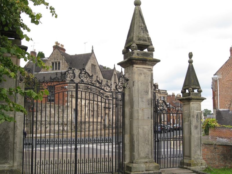
1.
783 (South-East Side)
Churchyard Gate Piers
and Gates to the parish
church of St Oswald
SK NE 1/109
GV
II*
2.
Circa 1700. Stone gate piers to main churchyard entrance at junction of Church
Street with School Lane (qv). Piers are panelled with panelled conical caps
supported with skulls with flames as finials. Cl8 iron gates with overthrow.
Nos 38, 40 and 72, together with Pegg's Almshouses, Owlfield's Almhouses, The
Mansion, the Summerhouse and the cobbled pavements form a group with the parish
Church of St Oswald and the churchyard gate piers, gates and walls.
The churchyard gate piers and gates, and the School Lane section of the churchyard
walls to the parish Church of St Oswald form a group with all the listed buildings
on School Lane and with No 69 Church Street.
Listing NGR: SK1767246490
External links are from the relevant listing authority and, where applicable, Wikidata. Wikidata IDs may be related buildings as well as this specific building. If you want to add or update a link, you will need to do so by editing the Wikidata entry.


Other nearby listed buildings
