Approximate Location Map
Large Map »
Latitude: 51.4579 / 51°27'28"N
Longitude: -0.9779 / 0°58'40"W
OS Eastings: 471111
OS Northings: 173703
OS Grid: SU711737
Mapcode National: GBR QKD.GV
Mapcode Global: VHDWT.0MD8
Plus Code: 9C3XF25C+4V
Entry Name: 29 and 31, Caversham Road
Listing Date: 14 December 1978
Grade: II
Source: Historic England
Source ID: 1113433
English Heritage Legacy ID: 38834
ID on this website: 101113433
Location: Reading, Berkshire, RG1
County: Reading
Electoral Ward/Division: Abbey
Parish: Non Civil Parish
Built-Up Area: Reading
Traditional County: Berkshire
Lieutenancy Area (Ceremonial County): Berkshire
Church of England Parish: Reading Greyfriars
Church of England Diocese: Oxford
Tagged with: Building
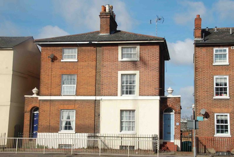
CAVERSHAM ROAD
1.
5128
(West Side)
Nos 29 and 31
SU 7173 12/426
II GV
2.
Circa 1847. 2 storey and basement pair. Red brick, with 1st floor cill band.
Hipped slate roof with central chimney. 1 bay each, glazing bar sashes. 1
bay set back porch extensions to sides each with urn on coping.
Listing NGR: SU7111173703
External links are from the relevant listing authority and, where applicable, Wikidata. Wikidata IDs may be related buildings as well as this specific building. If you want to add or update a link, you will need to do so by editing the Wikidata entry.


Other nearby listed buildings
