Latitude: 51.4559 / 51°27'21"N
Longitude: -0.969 / 0°58'8"W
OS Eastings: 471733
OS Northings: 173497
OS Grid: SU717734
Mapcode National: GBR QMF.FJ
Mapcode Global: VHDWT.5N3R
Plus Code: 9C3XF24J+9C
Entry Name: 13-16 Market Place
Listing Date: 26 July 1973
Last Amended: 31 July 2024
Grade: II
Source: Historic England
Source ID: 1113535
English Heritage Legacy ID: 39072
ID on this website: 101113535
Location: Reading, Berkshire, RG1
County: Reading
Parish: Non Civil Parish
Built-Up Area: Reading
Traditional County: Berkshire
Lieutenancy Area (Ceremonial County): Berkshire
Church of England Parish: Reading St Mary the Virgin
Church of England Diocese: Oxford
Tagged with: Bank building
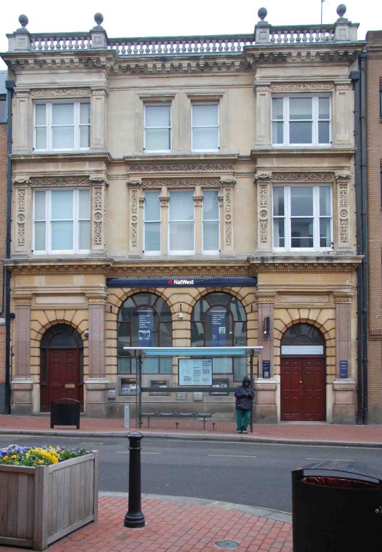
Former bank, constructed in around 1876 to the designs of Frederick William Albury of Albury and Brown.
Former bank, constructed in around 1876 to the designs of Frederick William Albury of Albury and Brown.
MATERIALS: the street-facing, west elevation is of ashlar Bath Stone with pink granite and Portland Stone embellishments. The roof covering over the street-facing range is slate. The later rear extensions are of red brick and render.
PLAN: 13-16 Market Place comprises a principal, street-facing volume of three storeys with projecting outer bays. To the rear (east) are a series of one- and two-storey extensions, all of which are rectangular in plan.
EXTERIOR: the principal elevation of 13-16 Market Place presents Italianate proportions and embellishments, with the outer bays framed on each storey by corner pilasters. At ground-floor level, these outer bays each contain an entrance doorway topped with a fan-shaped overlight and are set into rusticated concave jambs. Both doorways are framed by pilasters with tall plinths, pink granite shafts, and geometric circular capitals. They support heavy entablatures with cornices that also function as the cills of the first-floor windows. The centre bay of the ground floor contains two round-headed windows set into channelled rustication.
The first-floor windows are all tripartite, plate-glass sashes topped by decorative lintels and side pilasters with relief panel carvings and foliate capitals. The windows of the centre bay support an enriched entablature and have stone pilaster mullions. The tripartite plate-glass fenestration is continued in the northern and southernmost bays of the second storey, with the centre bay instead containing paired plate-glass sashes set into architraves. The flanking pilasters of the outer bays continue the circular motif of the ground floor in their capitals, and enriched lintels also top these outer windows.
At its apex, the building features a heavy modillion cornice that supports a Portland Stone balustrade with ball finials crowning the corners of the outer bays. The gable/pitched roof slopes east-west, with the east slope containing three skylights just below the roof ridge.
The first and second floors of the rear, east elevation are red brick and respectively feature two and three bays of fenestration. The entire rear of the building comprises a series of one- and two-storey, C20 extensions, mostly with felt roofing. The north elevation of these extensions is white-rendered.
Modest rural settlements likely existed in the area as far back as the first century. By the time of the Norman Conquest of 1066, Reading had become a town of notable size. After Reading Abbey was founded in 1121, the town grew substantially; spurred on by cloth production, the establishment of the new Market Place, and what would today be known as London Street, an extension to the High Street that facilitated trade to and from London. By 1525, the town’s thriving cloth industry led Reading to become the largest town in Berkshire. In 1542, Henry VIII’s royal charter made Reading a borough. Following significant upheaval during the Civil War, the town flourished during C18 and C19. Several developments during the late C18 and C19 spurred further growth and prosperity, including the arrival of the Great Western Railway, improvements to the navigability of the River Kennet, and the growth of the local brewing industry.
13-16 Market Place was constructed in around 1876, purpose-built for the London and County Bank and designed by the local architect Frederick William Albury (1845-1912) of Albury and Brown. By the late C19, the building contained several one- and two-storey ancillary extensions to its rear, east elevation, alongside an expansive rear garden. The ground floor contained the banking premises, while the upper floors functioned as private residences for banking staff. The general configuration of the site continued until the 1980s when the remaining open space to the rear was occupied with secondary extensions.
In the 1920s, the building became the Westminster Bank Limited, followed by the National Westminster Bank in 1968, later shortened to NatWest. NatWest vacated the building in 2020 and it is currently (2023) vacant.
External links are from the relevant listing authority and, where applicable, Wikidata. Wikidata IDs may be related buildings as well as this specific building. If you want to add or update a link, you will need to do so by editing the Wikidata entry.


Other nearby listed buildings