Latitude: 51.4561 / 51°27'21"N
Longitude: -0.9697 / 0°58'10"W
OS Eastings: 471683
OS Northings: 173513
OS Grid: SU716735
Mapcode National: GBR QMF.8G
Mapcode Global: VHDWT.4NQN
Plus Code: 9C3XF24J+C4
Entry Name: 23-26 Market Place
Listing Date: 26 July 1973
Last Amended: 13 May 2024
Grade: II
Source: Historic England
Source ID: 1113536
English Heritage Legacy ID: 39073
ID on this website: 101113536
Location: Reading, Berkshire, RG1
County: Reading
Electoral Ward/Division: Abbey
Parish: Non Civil Parish
Built-Up Area: Reading
Traditional County: Berkshire
Lieutenancy Area (Ceremonial County): Berkshire
Church of England Parish: Reading St Mary the Virgin
Church of England Diocese: Oxford
Tagged with: Building
Commercial terrace constructed in the early C19 to designs by Henry Briant and Nathaniel Briant.
Commercial terrace constructed in the early C19 to designs by Henry Briant (1813-1884) and Nathaniel Briant (dates unknown).
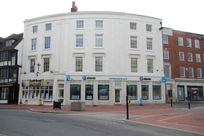
MATERIALS: the principal, east elevation is faced with rendered ashlar Bath Stone. The roof is slate and the rear elevations are exposed red brick.
PLAN: 23-26 Market Place comprises a single, four-storey volume divided into three properties. Owing to their shared convex east elevation, this volume is a quadrant in plan. The northernmost property comprises number 23, followed by number 24, with numbers 25-26 to the south.
EXTERIOR: the range is expressed as three properties, each two bays wide, with a shared convex east elevation. All three buildings have a largely glazed shopfront at ground-floor level with an entrance doorway at the intersection between each building. The three buildings are separated by coupled Doric pilasters with fluted capitals that span from the first floor to the building’s parapet. The upper floors of the three buildings have a shared 2:2:2 ratio of fenestration bays. The windows at first-floor level are six-over-six glazing bar sashes set into neoclassical cases and topped by cornices with carved brackets. The second-floor windows are also six-over-six glazing bar sashes set into neoclassical cases but without cornices. The third-floor windows are square, three-over-three sashes. The building features a continuous parapet with a moulded cope at its apex and a cornice spanning numbers 24-26. Numbers 25 and 26 are spanned by two pitched roofs oriented east-west, with one over the front, eastern half of the building, and another over the rear, western half. The front (eastern) halves of numbers 23 and 24 are spanned by a continuous hipped roof with its slopes oriented east-west, while the rear portion of both buildings is spanned by a flat roof. There are chimney stacks rising on the party wall of numbers 24 and 25, and between numbers 26 and 27. The rear elevation was not inspected. It is understood to contain various bays of fenestration, and a spiral staircase spanning numbers 25 and 26.
Modest rural settlements likely existed in the area as far back as the first century. By the time of the Norman Conquest of 1066, Reading had become a town of notable size. After Reading Abbey was founded in 1121, the town grew substantially; spurred on by cloth production, the establishment of the new Market Place, and what would today be known as London Street, an extension to the High Street that facilitated trade to and from London. By 1525, the town’s thriving cloth industry led Reading to become the largest town in Berkshire. In 1542, Henry VIII’s royal charter made Reading a borough. Following significant upheaval during the Civil War, the town flourished during C18 and C19. Several developments during the late C18 and C19 encouraged further growth and prosperity, including the arrival of the Great Western Railway, improvements to the navigability of the River Kennet, and the growth of the local brewing industry.
23-26 Market Place were constructed in the early C19 as a series of three buildings behind a single façade, attributed to the local architects Henry and Nathaniel Briant. As shown in Coates’s Map of Reading (1802), they replaced existing buildings on the site, explaining why numbers 25 and 26 may have been merged into a single building. By 1895, numbers 25 and 26 contained a drugstore, number 24 was a game shop, and number 23 was a hosier’s shop. The footprint of the buildings changed little throughout the C20. It is apparent the ground floors were replaced with modern shopfronts later in the C20, at which point it appears the interiors of numbers 23 and 24 were merged. Numbers 25 and 26 currently (2023) function as an estate agency with offices above, while numbers 23 and 24 function as a takeaway restaurant at ground-floor and basement level.
External links are from the relevant listing authority and, where applicable, Wikidata. Wikidata IDs may be related buildings as well as this specific building. If you want to add or update a link, you will need to do so by editing the Wikidata entry.


Other nearby listed buildings