Latitude: 51.4563 / 51°27'22"N
Longitude: -0.9696 / 0°58'10"W
OS Eastings: 471688
OS Northings: 173538
OS Grid: SU716735
Mapcode National: GBR QMF.9D
Mapcode Global: VHDWT.4NRG
Plus Code: 9C3XF24J+G5
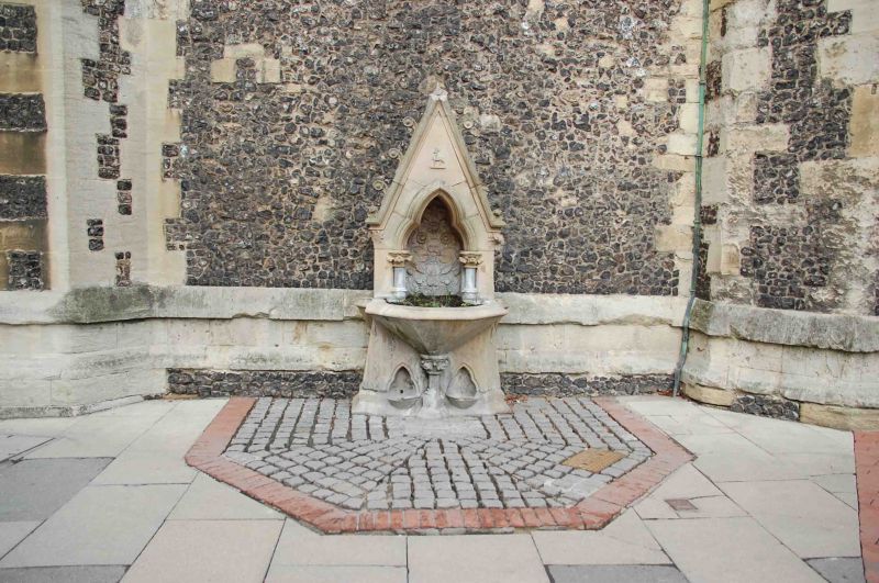
Entry Name: Drinking fountain on the south side of St Laurence’s Church tower, facing south towards Market Place
Listing Date: 26 July 1973
Last Amended: 4 March 2024
Grade: II
Source: Historic England
Source ID: 1156250
English Heritage Legacy ID: 39067
ID on this website: 101156250
Location: St Laurence's Church, Reading, Berkshire, RG1
County: Reading
Electoral Ward/Division: Abbey
Parish: Non Civil Parish
Built-Up Area: Reading
Traditional County: Berkshire
Lieutenancy Area (Ceremonial County): Berkshire
Church of England Parish: Reading St Laurence
Church of England Diocese: Oxford
Tagged with: Drinking fountain
Drinking fountain. Built in 1860 to the design of the architects William Ford Poulton and William Henry Woodman abutting the south elevation of St Laurence’s Church tower.
Drinking fountain. Built in 1860 to the design of the architects William Ford Poulton and William Henry Woodman abutting the south elevation of St Laurence’s Church tower.
MATERIALS: constructed of limestone with granite piers.
DESCRIPTION: the fountain has a broad limestone base carved with two trefoil-arched dog drinking basins flanking a miniature foliate column at its centre. On top of the column is an irregular hexagonal drinking basin surmounted by a large gothic gable with crockets on both its pitches, foliate ornament beneath its east and west eaves, and a small crocketed finial or fleche at its apex. The end of the gable contains a relief carving of a deer. Over the basin is a large trefoil arch with projecting hood, upheld by miniature flanking granite columns with foliate capitals. Recessed into the arch is a decorative panel with lotus ornament.
The first written record of Reading dates from a reference to a battle recorded in the Anglo-Saxon Chronicle in 871. By the time of the Norman Conquest of 1066, Reading had become a town of notable size. After Reading Abbey was founded in 1121, the town grew substantially, spurring cloth production, the establishment of the new Market Place, and what would today be known as London Street, an extension to the High Street that facilitated trade to and from London. By 1525, the town’s thriving cloth industry led Reading to become the largest town in Berkshire. In 1542, Henry VIII’s royal charter made Reading a borough. Following significant upheaval during the Civil War, the town flourished during the C18 and C19 and several developments spurred its growth, including the arrival of the Great Western Railway, improvements to the navigability of the River Kennet, and the growth of the local brewing industry.
The drinking fountain on the south side of St Laurence’s Tower is commonly known as the ‘Dog Fountain’. It was designed by the architects William Ford Poulton and William Henry Woodman in 1860 abutting the south elevation of St Laurence’s Church tower. It followed a national movement to provide towns with safe drinking water and was reported on positively in local newspapers when it was built. The bas-relied carving of the deer on the fountain is considered to be a reference to Psalm 42. The fountain originally had a taller finial that gave it a height of over three metres tall. The drinking fountain was restored in 1990 by Thames Water and Reading Borough Council, and further repaired by Reading Borough Council in March 2022.
The drinking fountain on the south side of St Laurence’s Church tower, built in 1860, is listed at Grade II for the following principal reasons:
Architectural interest:
* as a well-detailed and well-crafted drinking fountain of 1860, which contributes to the character of an architecturally varied historic streetscape.
Historic interest:
* as part of the urban development of Reading’s ancient core.
Group value:
* the structure is in close proximity to a large number of listed buildings and forms part of a strong historic grouping.
External links are from the relevant listing authority and, where applicable, Wikidata. Wikidata IDs may be related buildings as well as this specific building. If you want to add or update a link, you will need to do so by editing the Wikidata entry.


Other nearby listed buildings