Latitude: 51.4546 / 51°27'16"N
Longitude: -0.9743 / 0°58'27"W
OS Eastings: 471364
OS Northings: 173344
OS Grid: SU713733
Mapcode National: GBR QLG.70
Mapcode Global: VHDWT.2P8S
Plus Code: 9C3XF23G+R7
Entry Name: 55 and 55a St Mary’s Butts
Listing Date: 22 March 1957
Last Amended: 12 January 2024
Grade: II
Source: Historic England
Source ID: 1113572
English Heritage Legacy ID: 39154
ID on this website: 101113572
Location: Reading, Berkshire, RG1
County: Reading
Electoral Ward/Division: Abbey
Parish: Non Civil Parish
Built-Up Area: Reading
Traditional County: Berkshire
Lieutenancy Area (Ceremonial County): Berkshire
Church of England Parish: Reading St Mary the Virgin
Church of England Diocese: Oxford
Tagged with: Building
House, constructed during the early C19, converted to commercial use and extended to the east in around the mid-C19
MATERIALS: the upper floors of the building’s principal, west elevation are faced in Bath stone, while the south elevation is stuccoed. The east elevation is partially rendered and partially of exposed red brick. The western and central sections share a hipped, slate roof. The plain-tiled roof of the later, eastern range is pitched and contains four modern roof lights on its southern slope.
PLAN: the building occupies a rectangular plot extending eastward from St Mary’s Butts.It comprises a principal range (west) of three storeys across two bays facing onto St Mary’s Butts and four bays to the south. The a rear range to the east, added later, is two storeys across five bays to the south.
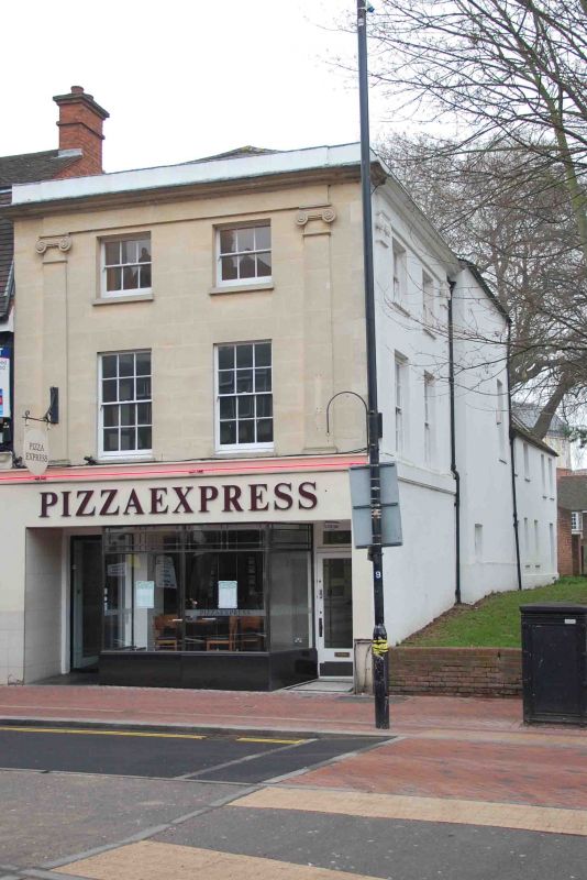
EXTERIOR: the principal (west) elevation has an altered, interwar shopfront on the ground floor, with a recessed doorway to the south with margin glazing bars, and a large canted shop window with metal framing and a margin-glazed upper section, and also a glass door to the north dating to around 2010. Above is a painted shop fascia. Within the Bath-stone-faced first and second floors are a pair of recessed timber sash windows on each floor; those on the first floor have six-over-six glazing, and those on the second floor having three-over-three glazing. The windows are flanked by a pair of two-storey ionic pilasters which are topped with a blank frieze. Above, there is a deep-projecting cornice with a parapet infront of the hipped roof. The upper floors of the two westernmost bays of the stucco-faced south elevation have the same window arrangement as the front elevation, and are also flanked by ionic columns; the ground floor is blank. Further east on this elevation there is an irregular fenestration with a three-over-three ground-floor nd six-over-six first-floor sash. The rear, mid-C19 east range has an irregular fenestration with timber sash windows of different proportions; six-over-six on the ground floor and three-over three on the first floor. The south elevation is blank, with exposed brickwork in a triangular shape indicating the former location of a demolished extension to the east. There is a small, single-storey, flat-roof brick extension attached to this elevation, with a modern door on its east elevation.
INTERIOR: not inspected
The crossroads formed by the north-south route of St Mary’s Butts and Bridge Street and the east-west route of Gun Street and Castle Street is believed to be the centre of the original Saxon settlement at Reading, established sometime before the ninth century, with the lowest crossing point of the River Kennet lying a short distance away to the south. The name St Mary’s Butts derives from the presence there, during the medieval period, of archery butts to satisfy the requirement at the time for all men to practice archery.
55 and 55a St Mary’s Butts was constructed during the early C19. The building does not appear to be depicted on Coates’ map of 1802. Probably built as a private dwelling. The building was extended to the rear (east) sometime before 1879, by which time was advertised for sale as a ‘spacious freehold business premises’ (Berkshire Chronicle, 15 March 1879, p1). It appears to have been in commercial use continuously since this time, the upper floors also being in commercial use by the later C20. In the mid-1990s, it was converted from office space to a restaurant. Possibly at this time, number 55 was combined with the adjoining property at number 56, with the ground floors forming a single restaurant unit. The principal, west elevation appears to contain an interwar shopfront which has been altered through recent refurbishment.
External links are from the relevant listing authority and, where applicable, Wikidata. Wikidata IDs may be related buildings as well as this specific building. If you want to add or update a link, you will need to do so by editing the Wikidata entry.


Other nearby listed buildings