Latitude: 51.9897 / 51°59'22"N
Longitude: -0.6194 / 0°37'10"W
OS Eastings: 494894
OS Northings: 233258
OS Grid: SP948332
Mapcode National: GBR F2D.66Q
Mapcode Global: VHFQY.68W1
Plus Code: 9C3XX9QJ+V6
Entry Name: Wall, Gatepiers and Gates Belonging to Old Church of St Mary
Listing Date: 16 March 1987
Grade: II
Source: Historic England
Source ID: 1113989
English Heritage Legacy ID: 38204
ID on this website: 101113989
Location: Woburn, Central Bedfordshire, MK17
County: Central Bedfordshire
Civil Parish: Woburn
Built-Up Area: Woburn
Traditional County: Bedfordshire
Lieutenancy Area (Ceremonial County): Bedfordshire
Church of England Parish: Woburn
Church of England Diocese: St.Albans
SP 9433-9533 WOBURN BEDFORD STREET (West Side)
8/101
- Wall, gatepiers and gates
belonging to Old Church of
St Mary
GV II
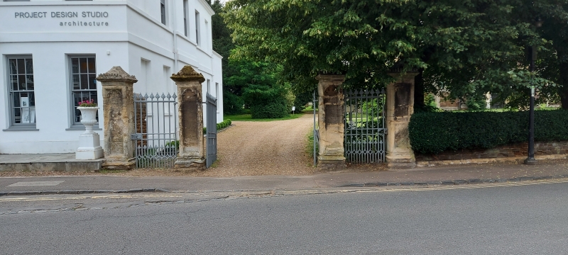
Wall, gatepiers and gates. Circa 1830 by Edward Blore. Ironstone with clunch
dressings. Adjoins Lower School to N, runs southwards bordering the pavement
and adjoins the Old Parsonage at S end. Approximately 45 metres long.
Gateway to LH. 4 piers form a central carriage entrance flanked by 2
pedestrian gateways. Clunch piers are approximately 2 metres high and square
in section. They have moulded bases, recessed panels with cusped heads,
moulded embattled cornices and pyramidal caps. Cast iron gates have
ornamental finials above toprails and to dograils of lower sections.
Churchyard wall is of coursed ironstone with ashlar coping, and stands about
half a metre high. Apparently originally supported piers and railings similar
in style to gateway.
(cf: illustration in J D Parry History and Description of Woburn and its
Abbey, 1831).
Listing NGR: SP9489433258
External links are from the relevant listing authority and, where applicable, Wikidata. Wikidata IDs may be related buildings as well as this specific building. If you want to add or update a link, you will need to do so by editing the Wikidata entry.


Other nearby listed buildings