Approximate Location Map
Large Map »
Latitude: 51.9894 / 51°59'21"N
Longitude: -0.6194 / 0°37'9"W
OS Eastings: 494896
OS Northings: 233231
OS Grid: SP948332
Mapcode National: GBR F2D.66T
Mapcode Global: VHFQY.68W7
Plus Code: 9C3XX9QJ+Q6
Entry Name: The Old Parsonage
Listing Date: 22 October 1952
Grade: II*
Source: Historic England
Source ID: 1321695
English Heritage Legacy ID: 38205
ID on this website: 101321695
Location: Woburn, Central Bedfordshire, MK17
County: Central Bedfordshire
Civil Parish: Woburn
Built-Up Area: Woburn
Traditional County: Bedfordshire
Lieutenancy Area (Ceremonial County): Bedfordshire
Church of England Parish: Woburn
Church of England Diocese: St.Albans
Tagged with: Clergy house
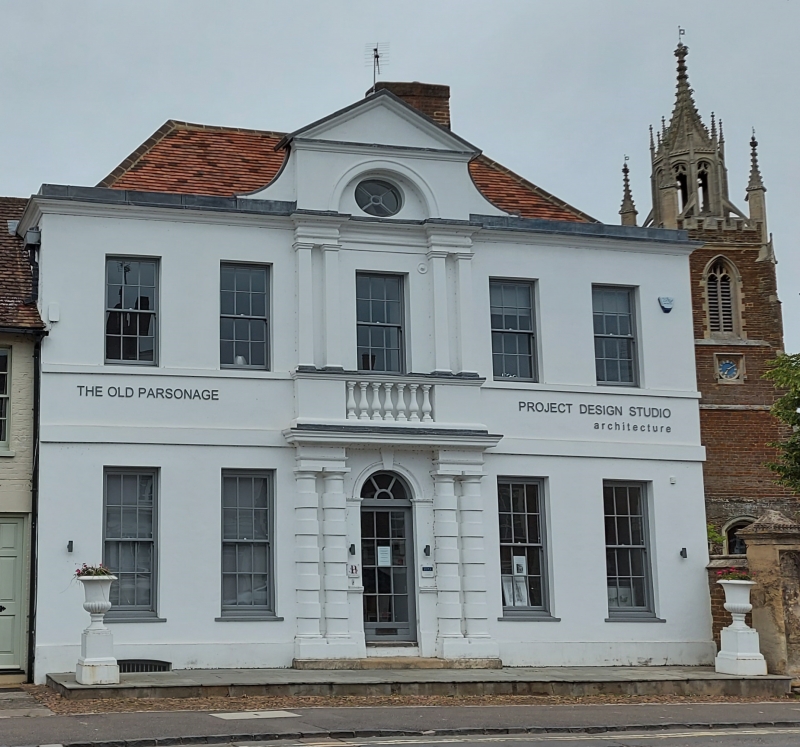
SP 9433-9533 WOBURN BEDFORD STREET (West Side)
8/102
22.10.52 The Old Parsonage
GV II*
House, formerly a parsonage. Ground floor used as commercial premises. Mid
C18, possibly encasing an earlier core. Painted brick and render. Steeply
pitched hipped clay tile roofs. L-plan, with main elevations towards road and
churchyard, giving appearance of double-pile plan. 2 storeys and attics.
Road elevation: symmetrical, with 2:1:2 windows. Outer bays are 2 storeyed,
with plinth, bands at first floor level and first floor sill level, and
moulded eaves cornice. Slightly projecting central bay, the ground floor with
pairs of engaged rusticated Tuscan columns supporting an entablature and
moulded cornice. Within this is a semi-circular arched doorway (formerly a
window) with impost bands, keystone and moulded archivolt, and containing C20
glazed door and semi-circular fanlight. First floor has blind balustrade,
from which rise 2 pairs of engaged antae. These support a moulded entablature
which is recessed in centre. The central bay rises above parapet, has a semi-
circular recess and is surmounted by a moulded pediment. Within the recess is
an oval oeil-de-boeuf. Ground and first floor windows are all sashes with
glazing bars, the first floor ones earlier, with heavy glazing bars. All are
under flat-arched heads. Churchyard elevation: originally the entrance
front. Symmetrical, with 2:1:2 sash windows. Similar arrangement to road
elevation, except that projecting central bay is plain, without columns, antae
or blind balustrade. First floor outer windows are blind, as is LH one to
ground floor. Attic has hipped dormer to LH. 6-panel door surmounted by
semi-circular fanlight. Substantial red brick ridge stack. Single-storeyed
addition to RH.
Listing NGR: SP9489633231
External links are from the relevant listing authority and, where applicable, Wikidata. Wikidata IDs may be related buildings as well as this specific building. If you want to add or update a link, you will need to do so by editing the Wikidata entry.


Other nearby listed buildings
