Approximate Location Map
Large Map »
Latitude: 51.8818 / 51°52'54"N
Longitude: -0.5945 / 0°35'40"W
OS Eastings: 496842
OS Northings: 221292
OS Grid: SP968212
Mapcode National: GBR F3L.SNJ
Mapcode Global: VHFRB.NY3S
Plus Code: 9C3XVCJ4+P6
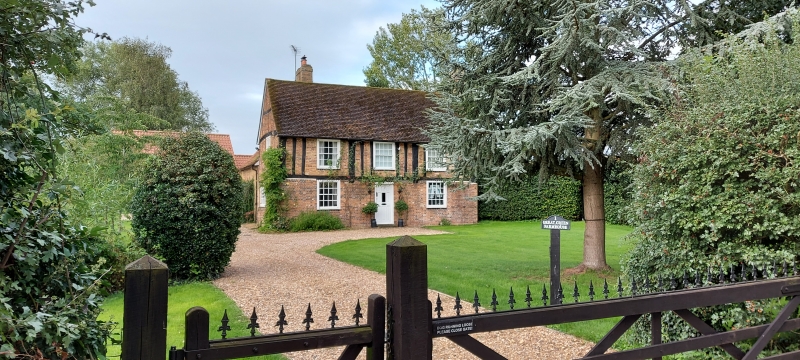
Entry Name: Great Green Farmhouse
Listing Date: 26 September 1980
Grade: II
Source: Historic England
Source ID: 1114673
English Heritage Legacy ID: 35935
ID on this website: 101114673
Location: Honeywick, Central Bedfordshire, LU6
County: Central Bedfordshire
Civil Parish: Eaton Bray
Built-Up Area: Eaton Bray
Traditional County: Bedfordshire
Lieutenancy Area (Ceremonial County): Bedfordshire
Church of England Parish: Eaton Bray with Edlesborough
Church of England Diocese: St.Albans
Tagged with: Farmhouse
1.
5125
SP 9621
30/92
EATON BRAY
THE RYE
Great Green Farmhouse
II
2.
C16. Timber-framed first floor with red brick nogging; red brick ground floor.
Two storeys. Modern tile roof. Three C19 flush sashes with glazing bars.
Listing NGR: SP9684221292
External links are from the relevant listing authority and, where applicable, Wikidata. Wikidata IDs may be related buildings as well as this specific building. If you want to add or update a link, you will need to do so by editing the Wikidata entry.


Other nearby listed buildings
