Approximate Location Map
Large Map »
Latitude: 51.9052 / 51°54'18"N
Longitude: -0.5995 / 0°35'58"W
OS Eastings: 496443
OS Northings: 223892
OS Grid: SP964238
Mapcode National: GBR F3C.K78
Mapcode Global: VHFRB.KCFS
Plus Code: 9C3XWC42+35
Entry Name: Old Farmhouse
Listing Date: 26 September 1980
Grade: II
Source: Historic England
Source ID: 1114729
English Heritage Legacy ID: 36067
ID on this website: 101114729
Location: Stanbridge, Central Bedfordshire, LU7
County: Central Bedfordshire
Civil Parish: Stanbridge
Built-Up Area: Stanbridge
Traditional County: Bedfordshire
Lieutenancy Area (Ceremonial County): Bedfordshire
Church of England Parish: Stanbridge
Church of England Diocese: St.Albans
Tagged with: Farmhouse
1.
5125 STANBRIDGE STATION ROAD
(west side)
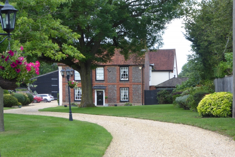
Old Farmhouse
SF 92 SE 36/266
II
2.
C18. Dark red brick with light red brick quoins and window dressings. Two storeys.
Old clay tile roof. Three sashes with glazing bars. Bracketed doorhood.
Listing NGR: SP9644323892
External links are from the relevant listing authority and, where applicable, Wikidata. Wikidata IDs may be related buildings as well as this specific building. If you want to add or update a link, you will need to do so by editing the Wikidata entry.


Other nearby listed buildings
