Approximate Location Map
Large Map »
Latitude: 51.9069 / 51°54'24"N
Longitude: -0.6014 / 0°36'5"W
OS Eastings: 496307
OS Northings: 224079
OS Grid: SP963240
Mapcode National: GBR F3C.JR4
Mapcode Global: VHFRB.JBDH
Plus Code: 9C3XW94X+QC
Entry Name: Five Bells Public House
Listing Date: 26 September 1980
Grade: II
Source: Historic England
Source ID: 1321307
English Heritage Legacy ID: 36064
ID on this website: 101321307
Location: Stanbridge, Central Bedfordshire, LU7
County: Central Bedfordshire
Civil Parish: Stanbridge
Built-Up Area: Stanbridge
Traditional County: Bedfordshire
Lieutenancy Area (Ceremonial County): Bedfordshire
Church of England Parish: Stanbridge
Church of England Diocese: St.Albans
Tagged with: Pub
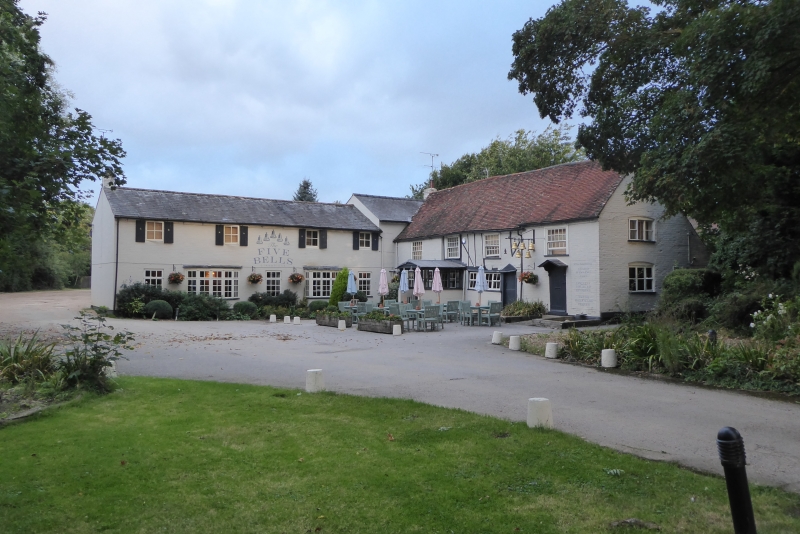
1.
5125 STANBRIDGE LEIGHTON ROAD
Five Bells Public House
SF 9624 26/256
II
2.
C17 with C18 wings. Whitewashed brick, some exposed timber-framing to centre of
first floor. Two storeys. Old clay tile roofs. 1:2:1 sash windows.
Listing NGR: SP9630724079
External links are from the relevant listing authority and, where applicable, Wikidata. Wikidata IDs may be related buildings as well as this specific building. If you want to add or update a link, you will need to do so by editing the Wikidata entry.


Other nearby listed buildings
