Approximate Location Map
Large Map »
Latitude: 53.2461 / 53°14'45"N
Longitude: -2.8708 / 2°52'14"W
OS Eastings: 341989
OS Northings: 372468
OS Grid: SJ419724
Mapcode National: GBR 8ZDX.83
Mapcode Global: WH881.WN4W
Plus Code: 9C5V64WH+CM
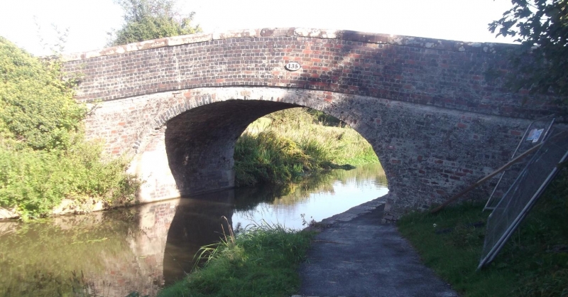
Entry Name: Croughton Bridge (135)
Listing Date: 20 December 1983
Grade: II
Source: Historic England
Source ID: 1115503
English Heritage Legacy ID: 55397
ID on this website: 101115503
Location: Croughton, Cheshire West and Chester, Cheshire, CH2
County: Cheshire West and Chester
Civil Parish: Croughton
Traditional County: Cheshire
Lieutenancy Area (Ceremonial County): Cheshire
Church of England Parish: Ellesmere Port Team
Church of England Diocese: Chester
Tagged with: Building Road bridge
SJ 47SW CROUGHTON C.P. WERVIN ROAD
4/14 Croughton Bridge (135)
II
Road bridge over Shropshire Union (Ellesmere) Canal. Circa 1795.
Mostly glazed brick with stone dressings. Single span semi-elliptical
arch, battered abutments. 2 course brick band at road level on outer
faces. Parapet has weathered sandstone coping.
Listing NGR: SJ4198972468
External links are from the relevant listing authority and, where applicable, Wikidata. Wikidata IDs may be related buildings as well as this specific building. If you want to add or update a link, you will need to do so by editing the Wikidata entry.


Other nearby listed buildings
