Latitude: 54.5838 / 54°35'1"N
Longitude: -1.2649 / 1°15'53"W
OS Eastings: 447608
OS Northings: 521198
OS Grid: NZ476211
Mapcode National: GBR MHLF.YM
Mapcode Global: WHD6Z.J1WV
Plus Code: 9C6WHPMP+G2
Entry Name: Phosphate Rock Silo Number 15 at Ici Works, Billingham
Listing Date: 7 October 1992
Grade: II*
Source: Historic England
Source ID: 1115821
English Heritage Legacy ID: 351259
ID on this website: 101115821
Location: Stockton-on-Tees, North Yorkshire, TS2
County: Stockton-on-Tees
Civil Parish: Billingham
Built-Up Area: Billingham
Traditional County: Durham
Lieutenancy Area (Ceremonial County): County Durham
Church of England Parish: Billingham
Church of England Diocese: Durham
Tagged with: Architectural structure
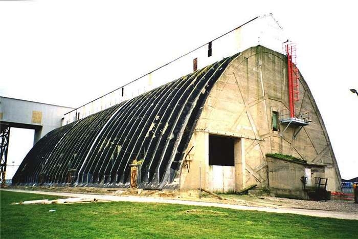
BILLINGHAM HAVERTON HILL ROAD NZ 42 SE 5154-/7/10001 Phosphate rock silo No 15 at ICI works, Billingham II* Phosphate rock silo. 1928/29. Reinforced concrete with steel gantry. 200 feet long, 80 feet wide and 47 foot 6 inches high, parabolic in cross section with re-inforced concrete arches. The silo is surmounted by a steel framed cage which contains a conveyor belt, this belt is linked to a further belt in its south tower which is linked to the steel gantry which runs down to the wharf. The ends of the silo have re-inforced concrete ribs and the floor contains a series of circular openings used for feeding the rock phosphate to the underground conveyor used for emptying this silo. This silo was designed by Monnoyer British Construction Ltd, for the storage of phosphate rock imported for the production of fertilizer. The parabolic shape allowed vast quantities to be stored without it causing structural problems on the sides of the buildings. This is the earliest surviving example of this type of silo in England.
Listing NGR: NZ4760821198
External links are from the relevant listing authority and, where applicable, Wikidata. Wikidata IDs may be related buildings as well as this specific building. If you want to add or update a link, you will need to do so by editing the Wikidata entry.


Other nearby listed buildings