Approximate Location Map
Large Map »
Latitude: 51.4123 / 51°24'44"N
Longitude: -1.1521 / 1°9'7"W
OS Eastings: 459065
OS Northings: 168482
OS Grid: SU590684
Mapcode National: GBR 93B.HJH
Mapcode Global: VHCZF.ZR9Q
Plus Code: 9C3WCR6X+W5
Entry Name: Bushnell Tomb Approximately 20 Metres to North of Tower of Church of St Mary
Listing Date: 10 November 1983
Grade: II
Source: Historic England
Source ID: 1117335
English Heritage Legacy ID: 39543
ID on this website: 101117335
Location: St Mary's Church, Beenham, West Berkshire, RG7
County: West Berkshire
Civil Parish: Beenham
Built-Up Area: Beenham
Traditional County: Berkshire
Lieutenancy Area (Ceremonial County): Berkshire
Church of England Parish: Beenham Valence
Church of England Diocese: Oxford
Tagged with: Tomb
BEENHAM
SU 56NE
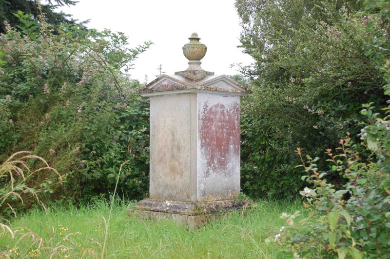
3/41 Bushnell Tomb
Approximately 20 Metres
To North Of Tower Of
Church Of St.Mary
GV II
Chest tomb. C.1815. Ashlar. Square, plan with moulded base, oval panels on all
faces with triangular pediments above, and topped with an urn finial.
Listing NGR: SU5906568482
External links are from the relevant listing authority and, where applicable, Wikidata. Wikidata IDs may be related buildings as well as this specific building. If you want to add or update a link, you will need to do so by editing the Wikidata entry.


Other nearby listed buildings
