Latitude: 51.3965 / 51°23'47"N
Longitude: -0.8797 / 0°52'46"W
OS Eastings: 478036
OS Northings: 166979
OS Grid: SU780669
Mapcode National: GBR C6K.DF5
Mapcode Global: VHDX7.P5S8
Plus Code: 9C3X94WC+H4
Entry Name: Wall to Barkham Manor
Listing Date: 17 January 1986
Grade: II
Source: Historic England
Source ID: 1118112
English Heritage Legacy ID: 41514
ID on this website: 101118112
Location: Barkham, Wokingham, Berkshire, RG41
County: Wokingham
Civil Parish: Barkham
Traditional County: Berkshire
Lieutenancy Area (Ceremonial County): Berkshire
Church of England Parish: Barkham
Church of England Diocese: Oxford
Tagged with: Wall
BARKHAM BARKHAM ROAD
SU 76 NE
(north west side)
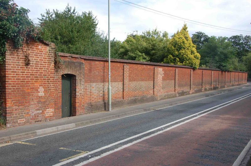
9/34 Wall to Barkham Manor
G.V. II
Wall. Early C19, enclosing the former kitchen garden and the stable court
to Barkham Manor. Brick with weathered top, 23 bays long with arched
door openings at Western end. Included for group value.
Listing NGR: SU7803666979
External links are from the relevant listing authority and, where applicable, Wikidata. Wikidata IDs may be related buildings as well as this specific building. If you want to add or update a link, you will need to do so by editing the Wikidata entry.


Other nearby listed buildings