Approximate Location Map
Large Map »
Latitude: 51.4798 / 51°28'47"N
Longitude: -0.8527 / 0°51'9"W
OS Eastings: 479772
OS Northings: 176272
OS Grid: SU797762
Mapcode National: GBR C5M.18M
Mapcode Global: VHDWW.52LF
Plus Code: 9C3XF4HW+WW
Entry Name: Armstrong Tomb Approx. 55 Metres South West of Tower of Church of St James
Listing Date: 23 December 1983
Grade: II
Source: Historic England
Source ID: 1118195
English Heritage Legacy ID: 41292
ID on this website: 101118195
Location: St James's Church, Ruscombe, Wokingham, Berkshire, RG10
County: Wokingham
Civil Parish: Ruscombe
Traditional County: Berkshire
Lieutenancy Area (Ceremonial County): Berkshire
Church of England Parish: Ruscombe and Twyford
Church of England Diocese: Oxford
Tagged with: Building
RUSCOMBE CHURCH LANE
SU 77 NE
(west side)
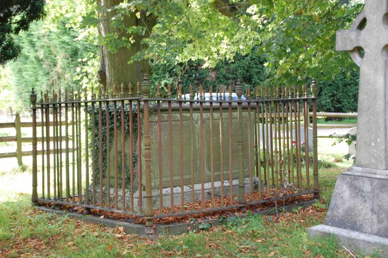
2/14 Armstrong tomb approx.
55 metres south west
of Tower of Church of
St. James
G.V. II
Chest tomb. C19 stone, moulded top, panelled sides and high palisade of
spear top iron railings with urns at centres and corners.
Listing NGR: SU7977276272
External links are from the relevant listing authority and, where applicable, Wikidata. Wikidata IDs may be related buildings as well as this specific building. If you want to add or update a link, you will need to do so by editing the Wikidata entry.


Other nearby listed buildings
