Latitude: 51.8894 / 51°53'21"N
Longitude: 0.8975 / 0°53'51"E
OS Eastings: 599489
OS Northings: 225169
OS Grid: TL994251
Mapcode National: GBR SN4.KQL
Mapcode Global: VHKFZ.HRVZ
Plus Code: 9F32VVQX+P2
Entry Name: 11A and 11B, High Street
Listing Date: 24 February 1950
Grade: II*
Source: Historic England
Source ID: 1123597
English Heritage Legacy ID: 116990
ID on this website: 101123597
Location: Colchester, Essex, CO1
County: Essex
District: Colchester
Electoral Ward/Division: Castle
Parish: Non Civil Parish
Built-Up Area: Colchester
Traditional County: Essex
Lieutenancy Area (Ceremonial County): Essex
Church of England Parish: Colchester St Peter
Church of England Diocese: Chelmsford
Tagged with: Building
1. HIGH STREET 995 (South Side) Nos 11A & 11B TL 9925 SW 4/88 24.2.50.
II*
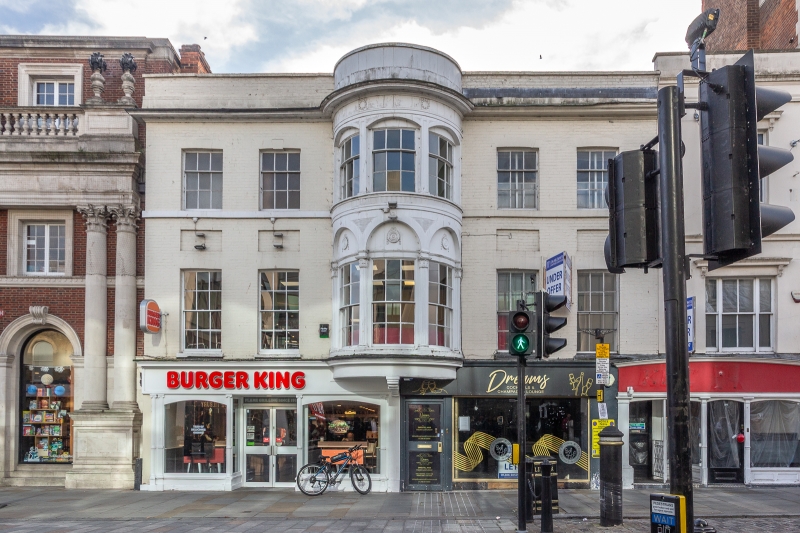
2. C17 house with good late Georgian front and it formerly had a fine interior ground floor room with painted panelling of circa 1700. The front is of 3 storeys, grey gault brick with parapet, 5-window range; the 1st floor has a large oriel window with arched treatment, fluted columns and decorations of medallions and swags, double hung sashes with glazing bars; the 2nd floor oriel has segmental arch treatment and large moulded cornice. Modern ground floor shop window, ground floor and basement used as shop and restaurant. The rear ground floor room now demolished had some exceptionally interesting painted panelling of circa 1700; the room was completely panelled, with bolection moulding and dentilled cornice, and there were paintings of architecture and landscape in the panels; panelled overmantel to fireplace in west wall.
Listing NGR: TL9948925169
External links are from the relevant listing authority and, where applicable, Wikidata. Wikidata IDs may be related buildings as well as this specific building. If you want to add or update a link, you will need to do so by editing the Wikidata entry.


Other nearby listed buildings