Approximate Location Map
Large Map »
Latitude: 51.5719 / 51°34'18"N
Longitude: -0.7769 / 0°46'36"W
OS Eastings: 484859
OS Northings: 186598
OS Grid: SU848865
Mapcode National: GBR D5W.GD4
Mapcode Global: VHDWB.HR3C
Plus Code: 9C3XH6CF+Q6
Entry Name: Obelisk
Listing Date: 16 July 1949
Grade: II
Source: Historic England
Source ID: 1125073
English Heritage Legacy ID: 46237
ID on this website: 101125073
Location: Marlow, Buckinghamshire, SL7
County: Buckinghamshire
Civil Parish: Marlow
Built-Up Area: Marlow
Traditional County: Buckinghamshire
Lieutenancy Area (Ceremonial County): Buckinghamshire
Church of England Parish: Great Marlow with Marlow Bottom, Little Marlow and Bisham
Church of England Diocese: Oxford
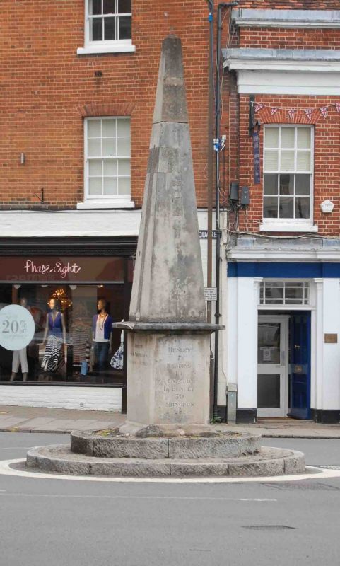
1. MARKET SQUARE
1385
(In the centre)
Obelisk
SU 8486 1/36 16.7.49.
II
2.
Stone obelisk erected in 1822 by the Trustees of the Reading and Hatfield
Road. Acts as a mile stone and sign post with directions on each side of
base.
Listing NGR: SU8485986598
External links are from the relevant listing authority and, where applicable, Wikidata. Wikidata IDs may be related buildings as well as this specific building. If you want to add or update a link, you will need to do so by editing the Wikidata entry.


Other nearby listed buildings
